June 9: Pu’u O’o Goes Poof Again

Today’s Eruption Summary

One gets the sense that crisis mode is giving way to some sort of new normal, as it did during the decades of the Pu’u O’o eruption. Not that one can ever call this normal:
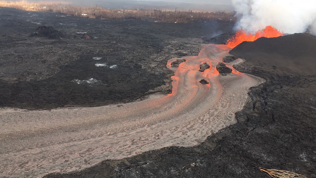
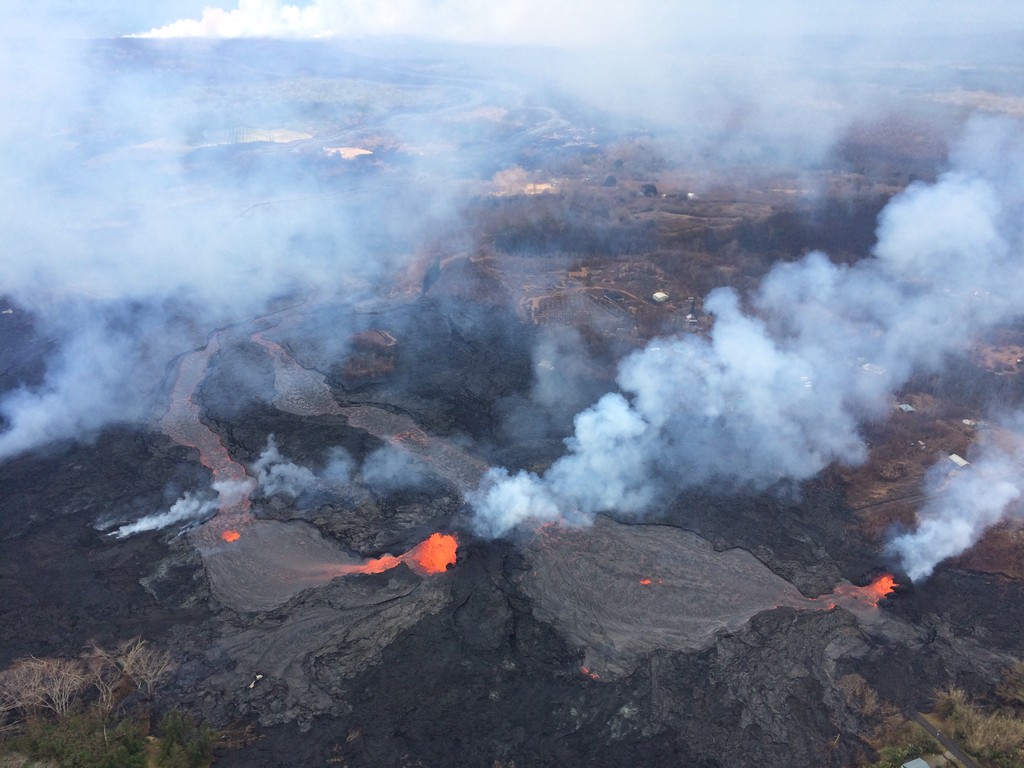
USGS: “Fissure 8 and lava channel in the lower East Rift Zone of Kīlauea Volcano during this afternoon’s overflight, with no apparent slowing in the eruption rate. The lava channel remained incandescent all the way around Kapoho Crater before entering the ocean.” (Full-sized)

Still, public meetings are no longer dominated by talk about lava, fissures, and SO2 so much as how to collect on insurance and find housing. The USGS has dropped weekend video briefings to give its staff a much-needed break (alerts/info are still posted on the HVO website). Hawaiian news outlets are reverting to a more typical news cycle, with only 1-2 new Kilauea updates a day.

At the summit, steam/ash explosions continue their recent pattern. Today’s explosion registered as M5.2 at 4:48am, shaking the village of Volcano; it was felt as far away as Hilo.  (Local radar is still out, but the ash cloud was small, less than 10,000 feet, since satellites can spot bigger ones).

Halema’uma’u is looking very ragged around the edges:
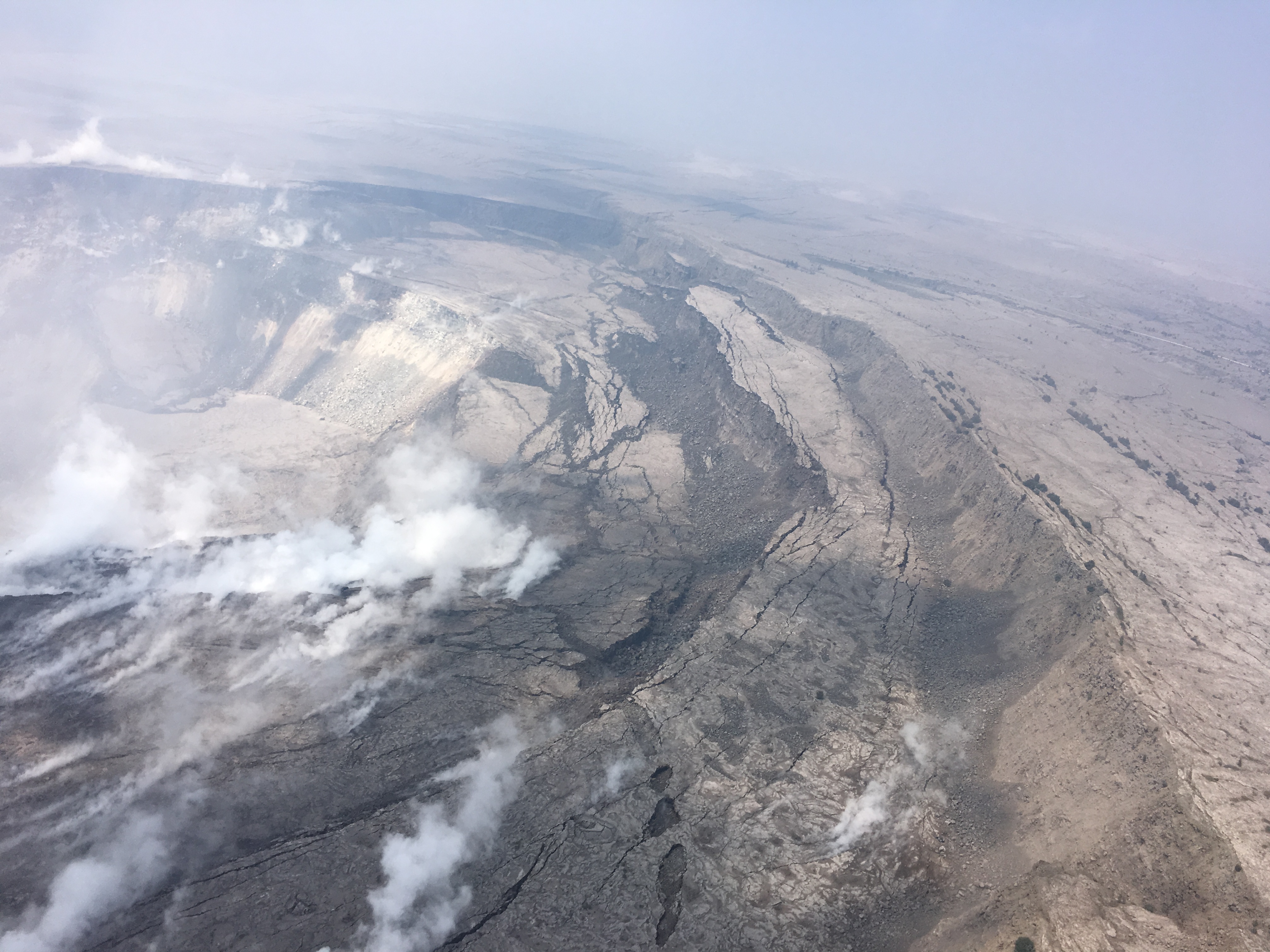
USGS: “Cracking and slumping of the Halema‘uma‘u crater walls are clearly evident in this aerial view captured during HVO’s overflight of Kīlauea’s summit this morning. Steam plumes have been rising from within the crater, as well as from cracks adjacent to the crater.” (Full-sized)

In the Lower East Rift Zone, Fissure 8’s fountain has tapered off slightly, down to 130-160ft with occasional bursts up to 200ft, but its lava river is still going strong.  As of 6:30am, the new lava delta at Kapoho had grown to 200 acres. An elevated section of the flow near Lava Tree State Park caused some concern this afternoon when it started overflowing its levee, but it settled back into the main channel without a major breakout.

[another amazing Fissure 8 overflight video from Mick; here’s his notes, including rough estimate from USGS: 6-9 million cubic yards per day!]

The Pu’u O’o webcam has even more scunge on it today than yesterday, when there was a few rockfalls and a brief plume of “rock dust.” There were more rockfalls this morning. Earthquake activity under Pu’u O’o is still negligible, however.

I’m running late tonight, so here’s a somewhat abbreviated weekend edition of USGS info, eruption news,  images and videos, including timelapses of the summit and fissure 8 for the past week:
Continue reading June 9: Pu’u O’o Goes Poof Again

June 5: Kapoho Bay Is No More

Today’s Eruption Summary:
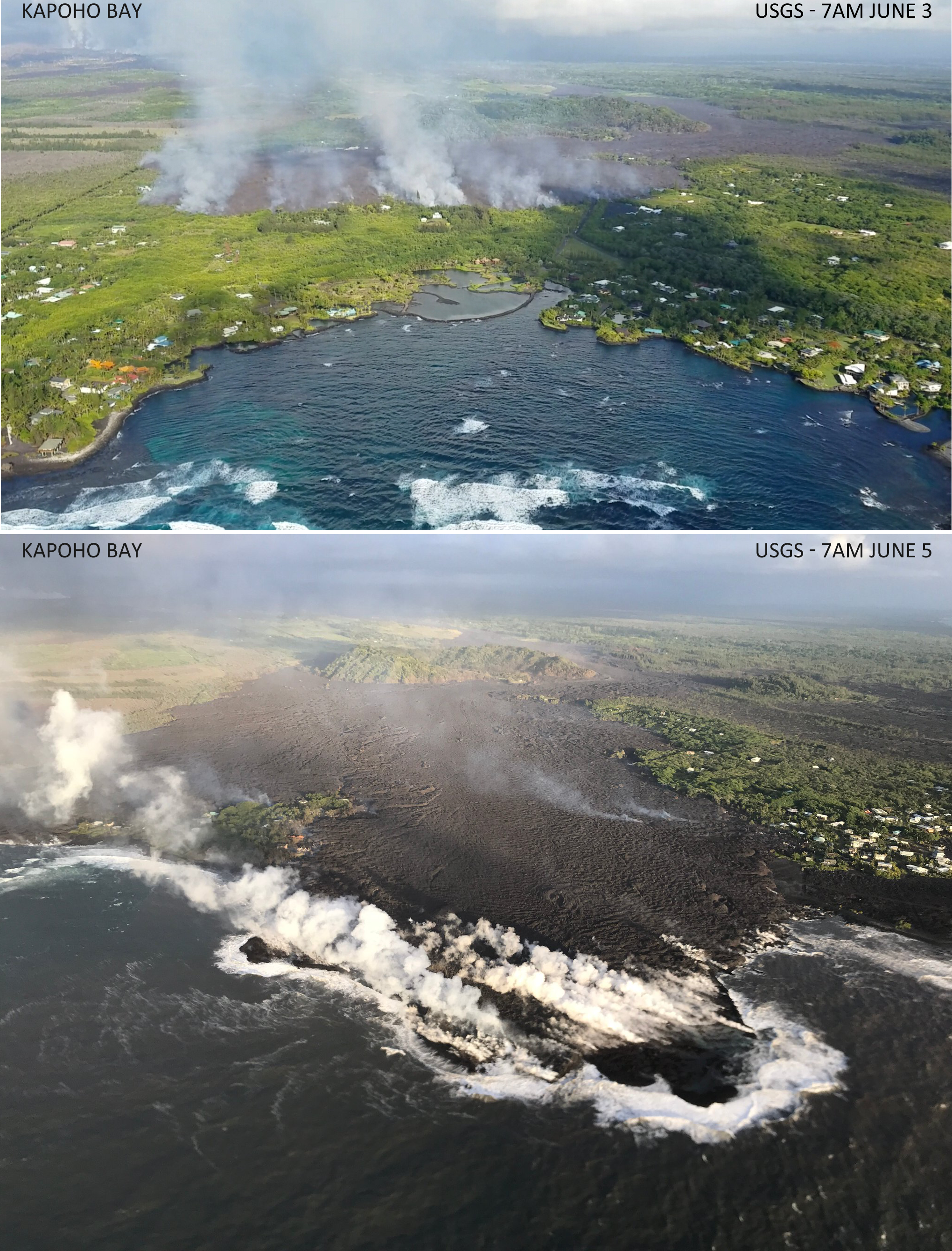
Kapoho Bay Before and After filled with Lava
USGS overflights of Kapoho Bay, morning of June 3 and June 5.

Lava reached Kapoho Bay on Saturday night, around 10:30. By Tuesday morning, it was Kapoho Point. There were hundreds of homes here, plus farms, tidepools, and marine life.

There’s really not much more one can say.

(See Mick Kalber’s observations/notes for this video)

There was another small predawn ash explosion up at Kilauea’s summit, where we can now watch the changes to Halema’uma’u Crater (see below). HI Civil Defense, the Dept. of Health and EPA have set up a new network of sensors to monitor and report air quality in realtime, which should help the rest of the island.

But Vacationland and Kapoho Beach Lots have now followed the 1960 village of Kapoho into memory.


Of course, that’s not the whole story for today. There’s new images and videos, USGS updates and info, articles on the eruption’s impact from local Hawaiian news outlets, and eyewitness reports and reactions on social media. So here’s the usual daily roundup of Kilauea eruption news.

Continue reading June 5: Kapoho Bay Is No More

June 4: Lava Enters Kapoho Bay

june 4 Kilauea Eruption Summary / Infographic by USGS
Text version at link: June 4 Kilauea Infographic, HVO/USGS

Latest numbers: 
Lava coverage ~7.7 square miles, 19.9 square km, 4917 acres.
Janet Snyder, spokesperson from Hawai’i County Mayor’s Office, says at least 117 homes destroyed, but Civil Defense admin Talmadge Magno says probably “a lot more”

Here’s a video clip and two screengrabs to sum up Kilauea’s activity today: a half-mile-wide a’a flow pouring into Kapoho Bay and slowly filling it, while the summit steams weakly after a 5.5 earthquake yesterday.

Kapoho Bay, USGS overflight, 6:13am (HST) this morning:

Screengrabs from the Halema’uma’u and LERZ webcams about 3pm:

Taken from Overlook Vent Wide Angle Webcam, HVO/USGS, Jun 4, 3pm local time. Only light steam.
Screengrab from USGS/HVO Lower East Rift Zone webcam, June 4, 3pm. Fissure 8 still fountaining away with broad lava flow issuing to right (northeast), heading down to Kapoho.

ETA: Oh, look. Perfect angle of the sun right now.

Jun 4, 6:20 pm – Nice webcam image from HVO.

Additional info from HVO morning status report: “Local videographers reported that lava entered the ocean at Kapoho Bay at about 10:30 PM HST on June 3. […] A lava breakout is also occurring upslope [north] of the Kapoho cone cinder pit, with active flows about 330 yards southeast of the intersection of Railroad Avenue and Cinder Road..   […]Following the small [M5.5] explosion at about 3:50 PM HST on June 3, earthquake activity at the summit has been low. Inward slumping of the rim and walls of Halema`uma`u continues in response to persistent subsidence. ”


June 4 Kilauea Eruption Digest:
  • USGS Info/Updates
  • Posts from Other Geologists
  • National Park Damage Report
  • News from Hawaiian Media
  • Images/Videos From Social Media

Continue reading June 4: Lava Enters Kapoho Bay

June 3: Kapoho’s Lava Woes and Guatemala’s Heartbreak

I write with a heavy heart tonight.

While Kilauea claims homes, possessions, and places people loved— and animals, sadly— it’s a relatively benign volcano (as long as it remains in its lava-gushing “effusive phase”). Its “ballistic rocks” can’t fly much farther than half a mile. Ash and vog hamper quality of life, but aren’t instantly deadly. Its lava moves slowly enough for people to escape. Lava creates new land while it destroys, and it breaks down eventually into fertile soil. While it’s destructive, it’s also beautiful:

This is a "waterfall" of lava pouring into Green Lake that is inside the Kapoho Crater on Green Mountain. The lake…

Posted by Don Hurzeler on Sunday, June 3, 2018

That’s the life’s blood of a shield volcano like Kilauea. But there’s another kind of volcano I’ve mentioned before: stratovolcanoes like Krakatoa and Mount St. Helens. Their silica-rich, stiff, sticky lava piles up into steep mountains that can bottle up tremendous pressure before letting go. I’m afraid that’s probably what happened in Guatemala today.

Careless news media (even the BBC!) are claiming that a river of lava from volcan del Fuego killed over 20 people and injured dozens more. But all the videos I saw (apart from videos of Leilani Estates passed off as Guatemala) show pyroclastic flows:

Not that scary-looking, eh? But nighttime shows the true face of a pyroclastic flow (Sinabung, Indonesia).

Dr. Janine Krippner pointed out this brief informative video explaining what pyroclastic flows are and why they’re so dangerous. Here’s the Spanish language version. Hearing-impaired? See What Is a Pyroclastic Flow? or ¿Qué son los flujos piroclásticos?

Please spare some compassionate thoughts for the Guatemalans caught in this eruption. Most of them probably thought those gray clouds were just (cooled) ash, like what’s irritating Hawaiians living downwind from Halema’uma’u. (No, Kilauea’s not going to do that.)

Today’s kilauea eruption summary
USGS caption: “Photo from 7AM helicopter overflight, hovering offshore and looking up the flowfront. Nearly all of the front was active and advancing; advance rates were estimated at an average of 250 feet/hour (76 m/hr), and as of 7AM the flow was 500 yards (457 m) from the ocean.” (Full-sized)

As for Kilauea, the main news today was fissure 8’s lava flow making its finall approach to the shore through the Kapoho Beach Lots/Vacationland area.

And as if in response to news media headlines claiming it’s “fallen quiet,” the summit woke up again with a whole popcorn-popper’s worth of earthquakes, including a beefy M5.5 in the afternoon and an ash cloud rising to 8,000 feet.

Here’s my daily digest of Kilauea eruption news, including:

  • Updates/info from the USGS and other geologists
  • eruption news from Hawaii Civil Defense
  • Local news stations covering the eruption and its impact
  • relevant social media posts by informed eyewitnesses

Continue reading June 3: Kapoho’s Lava Woes and Guatemala’s Heartbreak

June 2: Kapoho Isolated, Green Lake Evaporated

Today’s Eruption Summary:

After several days of anticipation, Fissure 8 arrived at last at Four Corners, the intersection of Highway 132 & 137. That gave local residents more time to retrieve their belongs before access to and from the Kapoho/Vacationland area was cut off.

USGS Caption: Northern edge of the fissure 8 flow front on the night of June 1, as it approached the intersection of Highways 132 and 137, known as “Four Corners.” (Full-sized)

Sadly, while people can evacuate, precious landmarks can’t. Today Green Lake seems to have gone the same way as the Queen’s Bath in Kalapana:

USGS Caption: “As fissure 8 lava flowed into Green Lake, the lake water boiled away, sending a white plume high into the sky—visible from afar between around 11:30 a.m. and 1:30 p.m. HST. This aerial photo, taken a couple of hours later by the Hawai‘i County Fire Department, shows still-steaming lava within Green Lake, located near the intersection of Highways 132 and 137.” (Full-sized)

Fissure 18 fell asleep before its flow could cross 137 again, but at this point, it hardly matters.

The summit was steaming with minimal ash today. However, news headlines claiming “crater falls quiet” may be greatly exaggerated. Time will tell.

USGS Morning Update

Continue reading June 2: Kapoho Isolated, Green Lake Evaporated

May 28: Rivers of Fire, Lava Livestream is back

Today’s Eruption Summary

About 7PM yesterday, a large pahoehoe flow suddenly burst out and went galloping through Leilani Estates. Civil Defense called for emergency evacuations. Firefighters had to guide one person to safety (with assistance of drone team tracking lava) when the flow covered his drivewayUSGS and Civil Defense reported that vigorous fountains 7 and especially 8 were responsible for the outbreak: fountaining 150-200 feet high, they built up a spatter rampart 100 feet tall and fueled a monster pahoehoe 20-40 feet thick. Speed augmented by the perched lava pond breaching (dam gave way, basically).

You can get a sense of last night’s outbreak from this timelapse of the Lower East Rift Zone webcam over the past few days.

The flows from yesterday slowed and stopped this morning. Most of the day’s activity was fairly subdued, with “only a minor ooze of residual lava” making it down to the ocean. But this evening, fissure 8 and other vents went into overdrive again, pouring out rivers of lava and prompting more emergency evacuations (Civil Defense notice) (HVO/USGS Alert).

Lava livestream

Honolulu Civil Beat is back to let us watch nature’s pyrotechnics from about 2km away and a crucial 200 feet up.

It’s mesmerizing to watch, but a sobering sight as well, knowing homes downstream are burning and some people are in danger. 

I can’t watch now; I have a post to write. Where was I? Continue reading May 28: Rivers of Fire, Lava Livestream is back

May 27: First Well Covered; Emergency Evacuations From Fast-Moving Lava

The dramatic light show I noticed on the East Rift Zone webcam last night was probably from fissure 7, featured on today’s Mick Kalber helicopter flyover (warning: noisy).


(Blog post: Mick Kalber’s observations from this flight)

Most of today’s news is about marauding lava flows in the Lower East Rift Zone, but the ESA just posted another satellite radar image of changes at Kilauea’s summit:


[EDIT] Things got a little TOO exciting this evening, and I kept having to update this post…

Continue reading May 27: First Well Covered; Emergency Evacuations From Fast-Moving Lava

May 25: End of the Road for Leilani Estates?

It looks like the coup de grace for Leilani Estates, or at least its eastern part.

USG Photo, May 25, noon overflight. Fissures 6 (left) and 13 (right) send lava flows south that join and flow down to ocean (white laze plume in distance). Note metal roof(?) embedded in lava at lower left. [Full-sized]
Three weeks ago Leilani’s streets were lacerated by fissures, battered by lava spattering from cracks, and blocked off by ponderous flows that seldom traveled far from their source. But that was a slow-motion disaster. Most fissures were active only a few hours. While a few unlucky residents lost homes in the first wave, most were able to return and collect vital possessions, or even risked dangerous fumes to stay.

Last week, the main lava activity shifted east, downrift, overrunning smaller Lanipuna Gardens, threatening the PGV geothermal plant, and inundating fields and woods where homes were more scattered.  “Hotter, fresher” magma arrived last Thursday with a roar, spurting in several-hundred foot fountains and flooding forests with rivers of fast-moving pahoehoe lava. On Saturday night, these channels reached the ocean.

It was only a reprieve. A few days ago, the fissures that had given Leilani grief began reactivating. The group of fountains monitored by HCB’s livestream began to subside as uprift vents pilfered their magma supply.  Leilani’s reinvigorated vents poured out so much lava they created a pond, as well as sending new flows down to the sea. And through people’s houses:

Today, more streets were buried. Firefighters went door-to-door urging the last holdouts to flee before lava reaches them. Even parts of lower Puna not yet menaced by lava were ordered to leave before their remaining escape routes are cut off. Just in case, authorities have sent in the Marines.

82 structures lost. A two mile stretch of fissures in a residential area is pouring out an astonishing 40-60 cubit feet per second. And yet only 3.4 square miles have been covered by lava in this eruption, on an island of over 4000 square miles. But that doesn’t make it any easier for those affected.

Below, a roundup of Friday’s images, videos, USGS news, and reports from local news stations.

Continue reading May 25: End of the Road for Leilani Estates?

May 24: USGS Acquires Drones, Leilani Estates Acquires Lava Lake

Before this, the main thing USGS was using drones for was LIDAR, but today’s Photo & Multimedia entry on HVO’s website provides drone footage for both the summit steam/ash plume and Leilani/Puna lava flows.

SUMMIT ERUPTION:

This video was filmed on May 21, 2018, with a UAV (unmanned aerial vehicle). Limited UAV flights above the hazardous Kīlauea summit area, which is currently too dangerous for geologists to enter for ground observations, are conducted with permission from the National Park Service. […] At Kīlauea Volcano’s summit, a nearly continuous plume of gas and steam billows out of the Overlook vent and drifts with the wind. Explosions are occurring about two times a day, producing ash that rises to a height of between 8,000 to 10,000 feet above sea level. Small ash emissions occur more frequently. The larger explosions produce ash that is blown downwind, and trace amounts have fallen in nearby communities.

Addendum: there was a 6PM 10,000 foot ash explosion & plume this evening (Civil Defense photo, USGS video), sending ash southwest.

PUNA LAVA ERUPTION:

This footage is from an Unmanned Aircraft System (UAS) hovering near fissure 22 during the overnight hours of May 22, 2018, and looking down on the fountaining fissure complex. The view rotates upward (to the south) to track channelized lava as it flows toward the Pacific Ocean, about 3 mi (5 km) away. The ocean entry is in the distance, recognizable by a small plume. The USGS National Unmanned Aircraft Systems Project Office is assisting with remote data collection and mapping of lava flows and hazards…

HVO’s Photo & Multimedia blog also posted impressive Hilo Civil Air Patrol aerial photos of the lava rivers from yesterday, as well as an image of Fissure 22 taking a nap (it’s still going but lower today on Civil Beat’s Livestream) while the fissures west of it (and uprift) that activated yesterday inundated Leilani Estates.

As an aside: people keep posting ridiculous rumors, so the USGS had to reassure everybody that Mauna Loa is NOT erupting.

Latest video this evening from HNN reporter Mileka Lincoln:

Earlier in the day… welcome to the Leilani Estates Lava lake. (warning: noisy)

The residents are being absolute champs in coping with this. Here’s another video clip of the lava lake with the homeowner whose home is just outside of it. They’re very philosophical, realizing they took a gamble, which is more mature than some of the people criticizing them for taking a chance on a place that hasn’t had an eruption in about 60 years. And they’re helping one another.

Oh, my mistake. It’s a lava pond.

Mick Kalber’s helicopter overflight video today does a great job of showing the “pond,” the fissures headed from there past the geothermal plant, and the lava rivers flowing south from those fissures towards the ocea.

USGS Updates, News Roundup, And More Vivid Videos:

Continue reading May 24: USGS Acquires Drones, Leilani Estates Acquires Lava Lake

May 22: Late Night News Roundup – More PGV Worries


First of all, Honolulu Civil Beat posted a video of Fissure 22 while his livestream cam  showcases the Fissure 20 complex.

Not that it really matters which is which, but I like to know what I’m looking at. 22 is sending lava down to the ocean (and the geothermal plant.)

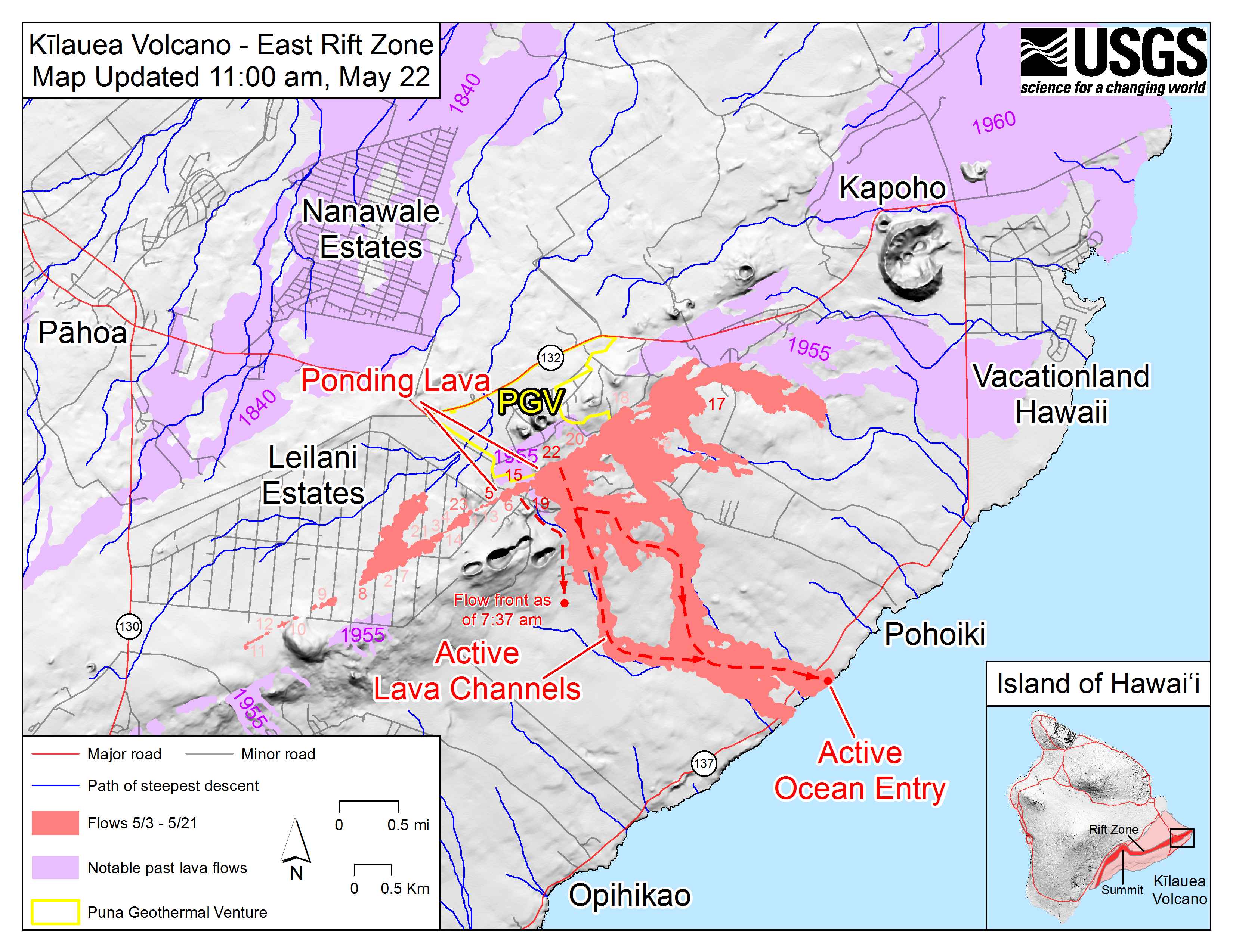
May 22 East Rift Zone Fissure Map by USGS

I think the livestream house is on that raised bump to the right of “PGV,” with the camera pointed SE. I guess this map was devised when 20 was having a low spell earlier today.

Mick Kalber’s usual stunning flyover vid including rivers of lava and lava flows meeting the sea:

Okay, now that we know where we are, what’s happening? Good images, clips and news tidbits after the cut. The main story today was concerns about lava encroaching on the PGV geothermal plant, and the hazards it poses. But first…

Continue reading May 22: Late Night News Roundup – More PGV Worries