Today’s Eruption Summary
About 7PM yesterday, a large pahoehoe flow suddenly burst out and went galloping through Leilani Estates. Civil Defense called for emergency evacuations. Firefighters had to guide one person to safety (with assistance of drone team tracking lava) when the flow covered his driveway. USGS and Civil Defense reported that vigorous fountains 7 and especially 8 were responsible for the outbreak: fountaining 150-200 feet high, they built up a spatter rampart 100 feet tall and fueled a monster pahoehoe 20-40 feet thick. Speed augmented by the perched lava pond breaching (dam gave way, basically).
You can get a sense of last night’s outbreak from this timelapse of the Lower East Rift Zone webcam over the past few days.
The flows from yesterday slowed and stopped this morning. Most of the day’s activity was fairly subdued, with “only a minor ooze of residual lava” making it down to the ocean. But this evening, fissure 8 and other vents went into overdrive again, pouring out rivers of lava and prompting more emergency evacuations (Civil Defense notice) (HVO/USGS Alert).
Lava livestream
Honolulu Civil Beat is back to let us watch nature’s pyrotechnics from about 2km away and a crucial 200 feet up.
It’s mesmerizing to watch, but a sobering sight as well, knowing homes downstream are burning and some people are in danger.
I can’t watch now; I have a post to write. Where was I?
Kilauea’s summit. Same old, same old. Frequent earthquakes up to M4.4 at 5:42pm, ongoing deflation, intermittent ash explosions, about once an hour this morning reaching 12,000, 13,000 and 15,000 feet. Civil Defense warned ¬that light easterlies would blow ash and vog west, aggravating a slightly different set of downwind communities.
Also, I keep forgetting to mention all the cracks across lower Puna due to the magma moving underneath. It doesn’t have to erupt to cause big problems:
Omg those cracks opening up through people's properties and homes 😮https://t.co/QnFibZLqkw pic.twitter.com/hbqIdbVK51
— Dr Janine Krippner (@janinekrippner) May 29, 2018
Note that this tweet points to a treasure trove of eruption images/vids: Hawaii Civil Defense’s Flickr album.
Here’s some more surprises from last night: volcanic cinder, Pele’s hair, and an honest-to-gosh Pele’s tear!
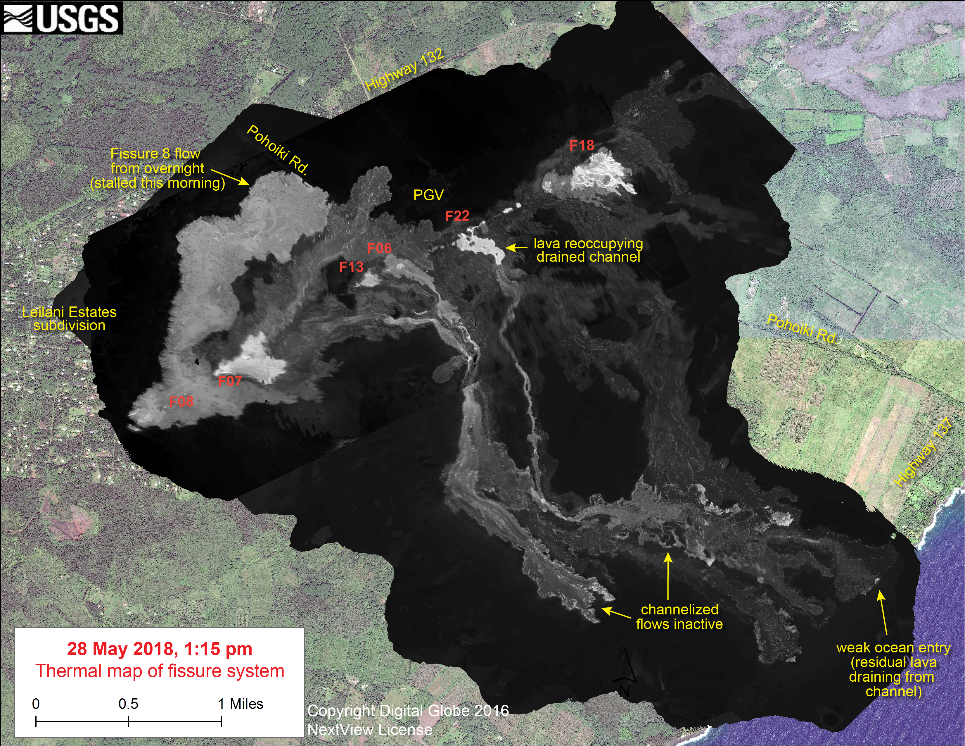
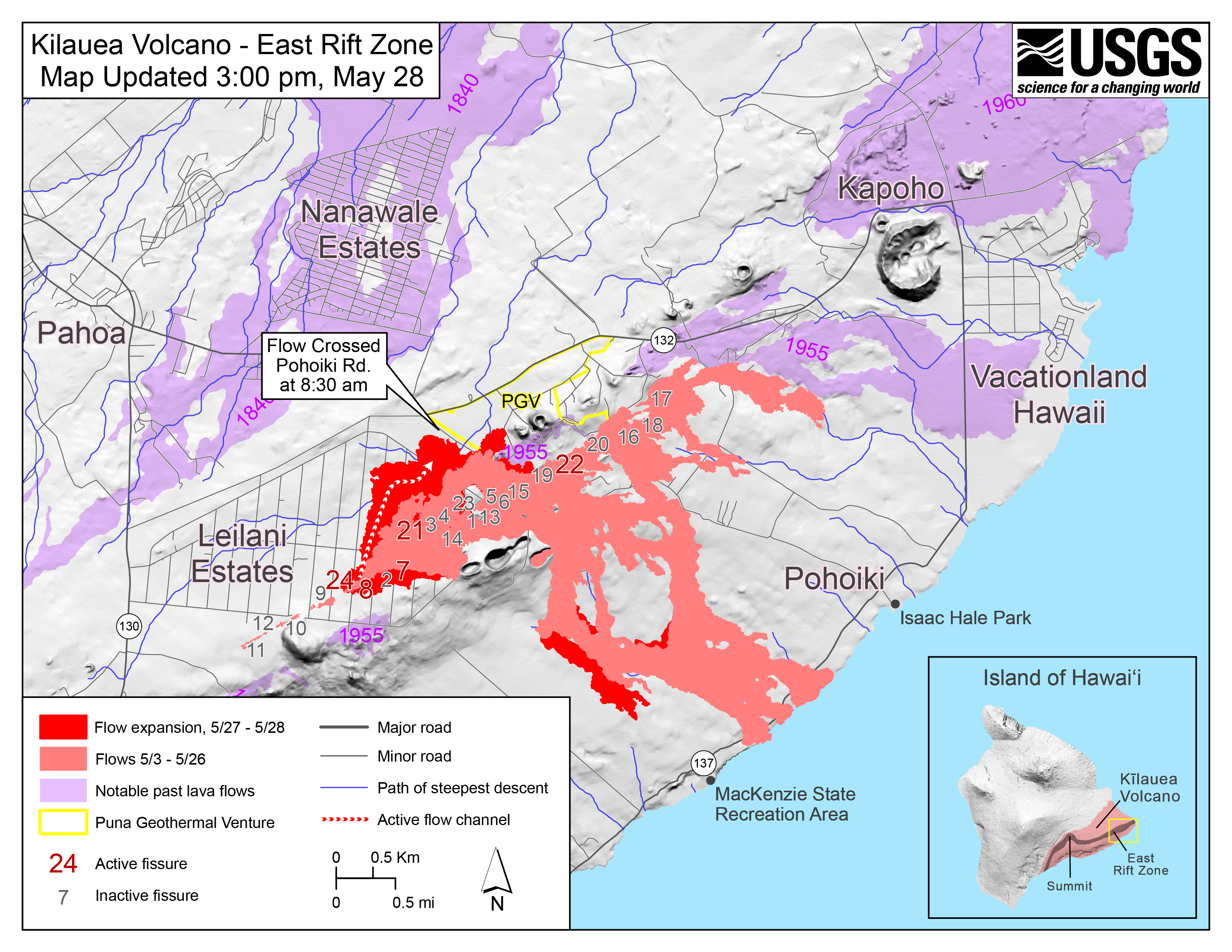
TODAY’S USGS Fissure Maps
A close look helps explain the day’s events. It’ll be interesting to see how tonight’s lava rivers rewrite the map tomorrow.
USGS May 28 Morning Status Update
Dr. Carolyn Parcheta, USGS Geologist, covers last night’s lava outbreak. Text transcript here.
USGS Images POSTED TODAY
@USGSVolcanoes, the channel not only for the Hawaii Volcanoes Observatory but its sister observatories (CVO, AVO, etc) is posting status updates + photos on Twitter:
Late-night #HVO #Kilauea update (11:35 PM HST May 27): LERZ fissures 7 and 8 v. active, fountaining. Fast-moving flow @ 7PM HST went N & W thru East #LeilaniEstates, caused evacuation. No significant ash plumes at summit, but continued small explosions. https://t.co/VVf7w28JKl pic.twitter.com/c3QBBQRMKW
— USGS Volcanoes🌋 (@USGSVolcanoes) May 28, 2018
Photos uploaded to HVO’s website today were mostly bleak aerial shots capturing the desolation of the greatly-expanded lava fields. Here’s Pohoiki Rd being menaced by last night’s galloping lava flow (now spread out and slower) at 7 AM.

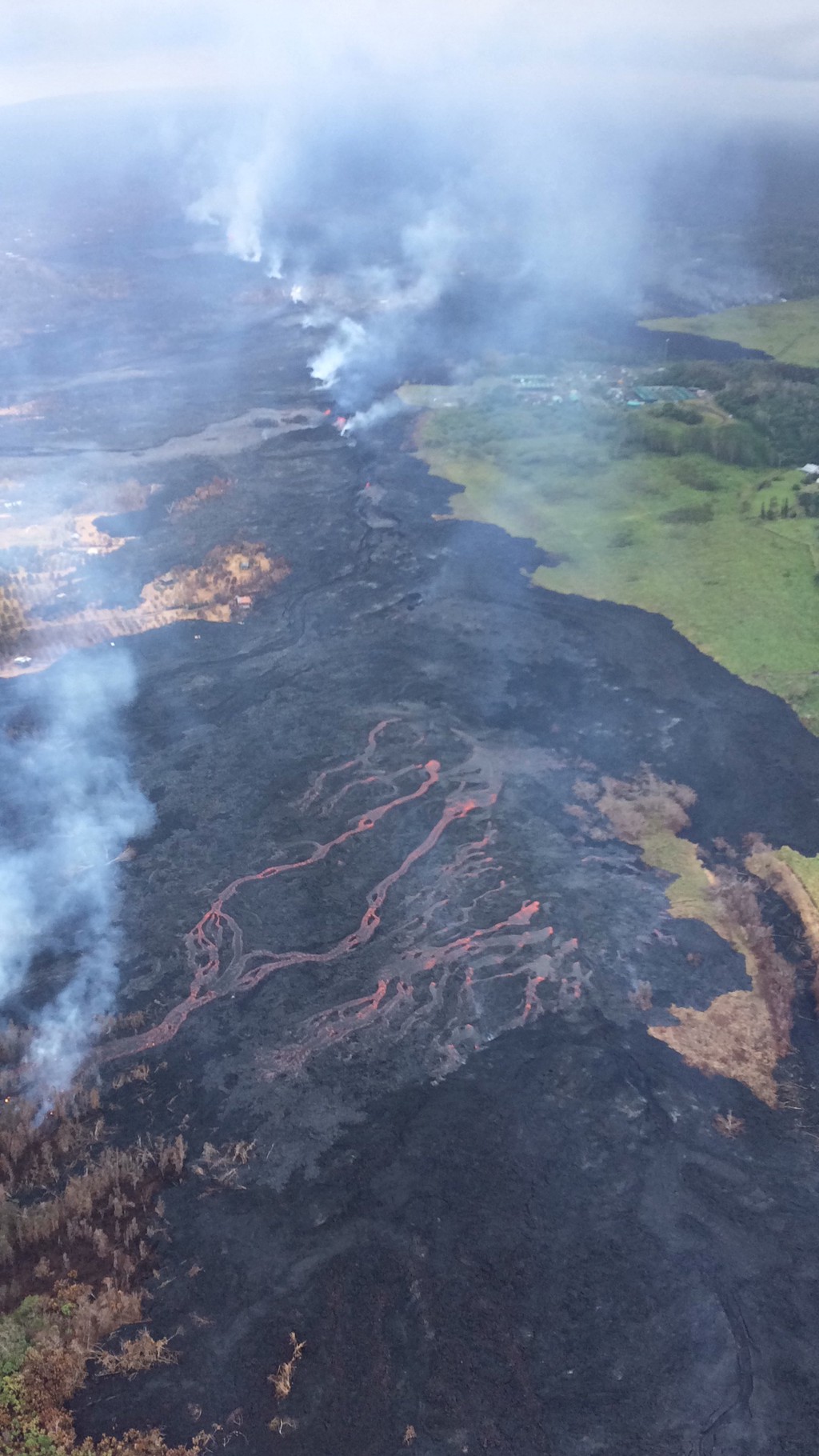
Here’s roughly the same view this afternoon, turned a little more clockwise. Pohoiki Rd is in both of them.
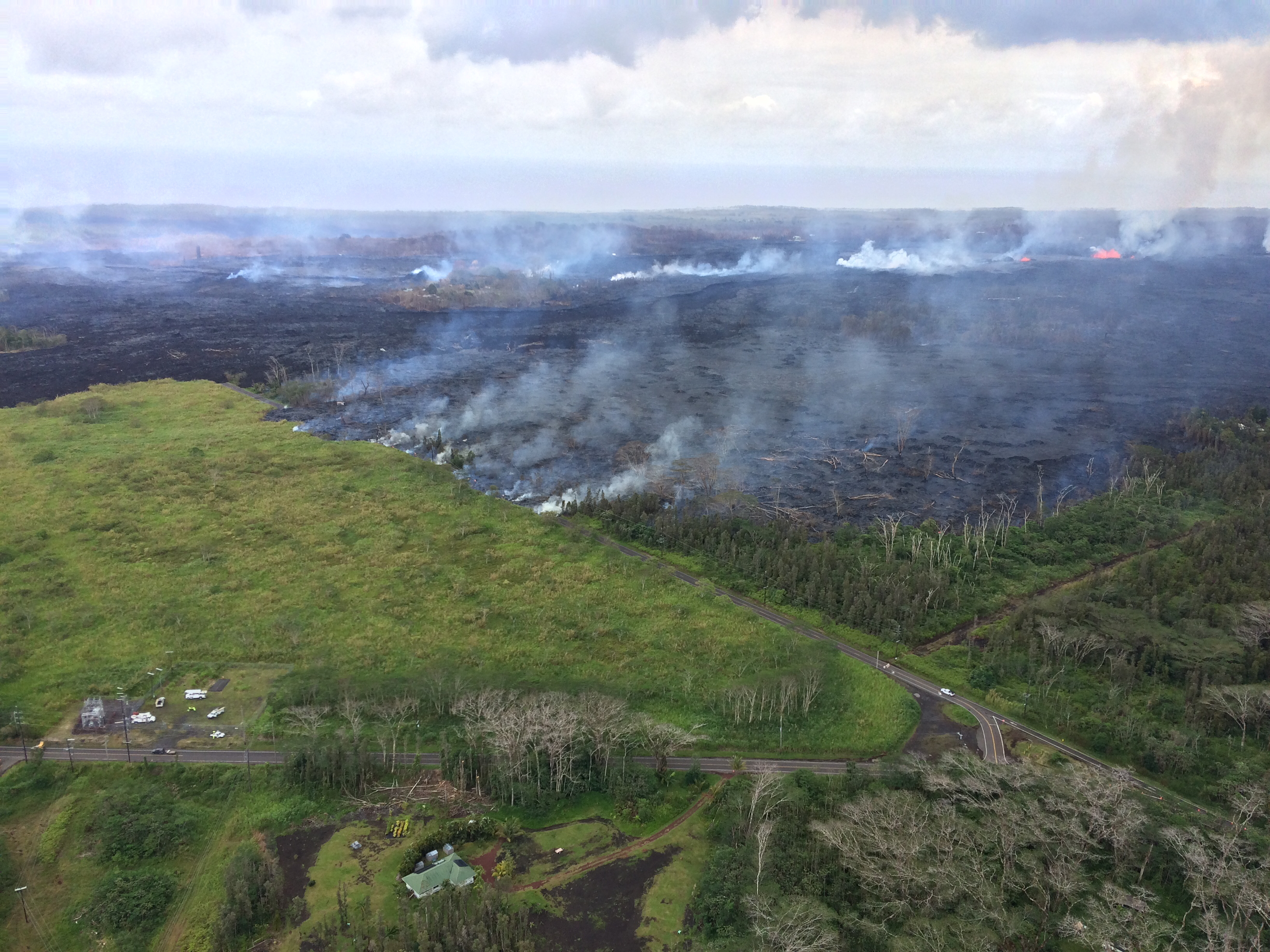
View of the now-sluggish lava flow that crossed Pohoiki Road earlier today; the flow originated from fissure 8. This fissure was very active overnight, slowed this morning, and stopped by about noon. During the close of an overflight this afternoon, lava began erupting downrift of fissure 8 in the area between about fissure 7 and 21 (low fountains in upper right). This photo was taken at about 1:45 p.m. HST. Compare with photo above. (Full-sized; worth seeing)
And here’s another bleak view which I think includes the geothermal plant plus the fissures 16-20-22 complex (middle of photo) which was the main focus of HCB’s lava livestream last week. You’ll probably want to see the full-sized version.
(Full-sized)
11am USGS Conference Call:
Below this video on BIVN’s website, there’s more USGS info, notices from civil defense, and info about power/roads for residents.
[Summary]
Steve Brantley (USGS): Describes last night’s major lava outbreak (new flow was 1.5 miles by mid-morning) and summarizes current activity at summit.
Jessica Ferracane (Hawaii Volcanoes National Park): Day 18 of park’s closure, tells media nope, no access; when USGS and park rangers are staying away for safety it’s dangerous! (But she did go up there yesterday and was pretty unnerved).
(Jon Jelsma) NWS: A weather forecast. Gist: wimpy winds through Tuesday may send ash, vog in different areas (including Pahoa, even Hilo) before trades come back. Heavy rain later tonight/Tuesday may help clear air.
Questions from news media. One asks if lack of new magma moving into LERZ (signified by lack of earthquakes) means it may stop. Brantley clarifies that it’s still receiving magma from summit, just not accumulating more, i.e. it’s erupting as fast as it’s being supplied.
Question about drones used last night to rescue trapped resident: Steve says team of pilots has been tracking lava, changes at summit, and more for both USGS and civil defense, so were able to track flow for first responders.
Geologists Around the Web
Dr. Robin Andrews tries out a few common solutions (bombs, diversion, water), then asks Dr. Janine Krippner: “Why Can’t We Artificially Drain Magma Chambers To Stop Volcanic Eruptions?”
Reports From Local News Media
- HNN reporter Mileka Lincoln posted a Civil Defense flyover and interview with USGS Dr. Jim Kauahikaua giving exclusive details about last night’s eruption.
HawaiiNewsNow and Honolulu Star-Advertiser have some articles they just keep updating:
- Lava eruptions in Lower East Rift Zone/Puna
HNN: “Fast-moving lava flow threatens more homes in Lower Puna”
HSA: “Residents told to get out now after fast-moving lava flow emerges in Leilani Estates” - Summit explosions, earthquakes, ashfall
HNN: “Residents warned of hazardous air quality as explosions ramp up at Kilauea summit.” (more details on ashfall)
HSA: “Overlook Crater vent broadens as rocks become ammo for future blasts” (more details on changes within crater) - Puna geothermal plant hazards, lava
HNN: “Lava covers 2 wells at Puna geothermal plant before stalling”
HSA: “Lava speeds up and bears down on Puna geothermal wells” - Trapped by lava/rescued:
HSA: “Holdouts warned to prepare to flee fast-moving lava on short notice”
HNN: “Firefighters rescue Puna man trapped by fast-moving lava flow”
KITV: guy refused to leave despite friends’ pleading until trapped. (Warning: annoying autoplay ads on this site I can’t seem to stop.) - Hawaii Volcano Observatory’s temporary headquarters
- HSA: “Hawaiian Volcano Observatory finds temporary home at UH-Hilo”
(BigIslandNow: “UH Hilo Opens Its Doors to HVO”
Other miscellaneous articles
- HNN: “The lava field created by ongoing Big Island eruptions would cover most of urban Honolulu” has an overlay map plus other analogies to help one visualize the numbers: how many acres, how tall (fountains), etc. Chart of past eruptions for comparison.
- HNN: “A lava photographer finds a new role: getting vital information to neighbors in need” – profile and photography of Demian Barrios.
- KITN: “Lanipuna Gardens resident claims being stranded for almost 12 days” WARNING: annoying autoplay ad one can’t see or disable
- HNN: “Here’s where all the fissures in lower Puna have opened up” is a daily-updated map and list by street.
From the Twitterverse (I don’t do FB, sorry):
Aerial photo from Bruce Omori this AM shows how close the lava flow is to highway 132 #Kilauea #Hawaii pic.twitter.com/ltJkMnqb5e
— Anthony Quintano (@AnthonyQuintano) May 28, 2018
Volcanoes can make weather! #HVO scientists are beginning to observe "pyrocumulus" clouds forming over the #LeilaniEstates fissure system. They form when intense heating of the air from the ground induces convection, and moisture condenses in the warm ai… pic.twitter.com/pGsbxyuDV9
— Katie Unger (@kungerwebs) May 29, 2018
This is what is falling from Sky in #LeilaniEstates atm. Evac underway. See prev tweets. 4.4 set things off 1 hr ago. #Hawaii 🌺 Stay safe! pic.twitter.com/qu6jVDo5s1
— Christina RadChick Consolo ☢ (@RadChick4Cast) May 29, 2018
We are seeing lava fountains at Leilani Estates from our location in Hilo ~ 25 miles away. My estimate is they are reaching 400 feet heights.
— Joel K. LaPinta (@jklapinta) May 29, 2018
#LeilaniEstatesEruption #KilaueaVolcano LATEST: @CivilDefenseHI says anyone still inside #LeilaniEstates needs to LEAVE NOW due to a dangerous fast-moving flow from Fissure 8 advancing on Nohea and Kupono St north of Leilani St https://t.co/qCwbT9qyKz @HawaiiNewsNow #HINews pic.twitter.com/7swNjrimSE
— Mileka Lincoln (@MilekaLincoln) May 29, 2018
The view from Ainaloa tonight… fissures are firing. #Kilauea #LeilaniEstates #Eruption #FriendsInAinaloa pic.twitter.com/arWzm9POHk
— Lynn Kawano (@LynnKawano) May 28, 2018