About the 1790 Kilauea Eruption

Here’s a summary and primary sources collected by HVO geologist Don Swanson on a 1790 explosive episode of Kilauea.

Also see USGS factsheet, “Explosive Eruptions at Kilauea, Hawai’i?” compiled prior to the 2018 eruptions. Diagram from this page:
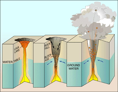
3-part diagram: at left, a full lava lake with a long chimney of magma supplying it from below; in the middle is the same lava lake with the lava level dropping way down the chimney, below the water table, so that the upper walls of the chimney are cool enough for groundwater to seep in. Rocks falling from the chimney's walls are starting to choke it. The third and last phase of the diagram shows that groundwater has heated to steam and built up pressure below the rockfall until it builds up enough steam to shoot the blockage straight up out of the chimney.
USGS Diagram Explaining Cause of Steam Eruptions

The factsheet notes that “Many of Kilauea’s pre-1924 explosive eruptions that produced significant ash deposits probably happened when the volcano’s summit crater was so deep that its floor was below the water table, letting ground water seep in to form a lake.

If I’m understanding correctly, they’re saying that bigger explosions may happen when there’s a lake of water, i.e. more fuel to create steam.

Edited to add: HVO’s page outlining the history of Kilauea Caldera also goes into past explosive episodes. Final paragraph:

“Having pieced together the recent geologic past of Kīlauea, scientists conclude that the volcano will eventually return to a long period of mostly explosive activity, just as it did around 1500 CE. This future explosive period will probably accompany a significant decrease in the magma supply rate and be initiated by collapse of a new caldera to the depth of the water table, which today is about 615 m (2015 ft) below the present high point on the caldera rim. For now, effusive eruptions dominate Kīlauea.”

Note: that’s a new caldera, the much larger basin containing Halema’uma’u crater within it, and the vent that’s erupting ash explosions right now was a small lava lake covering only part of the floor of Halema’uma’u. Orders of magnitude different in terms of size. Also, changing the location of the active vent doesn’t mean the magma supply inside is dropping.

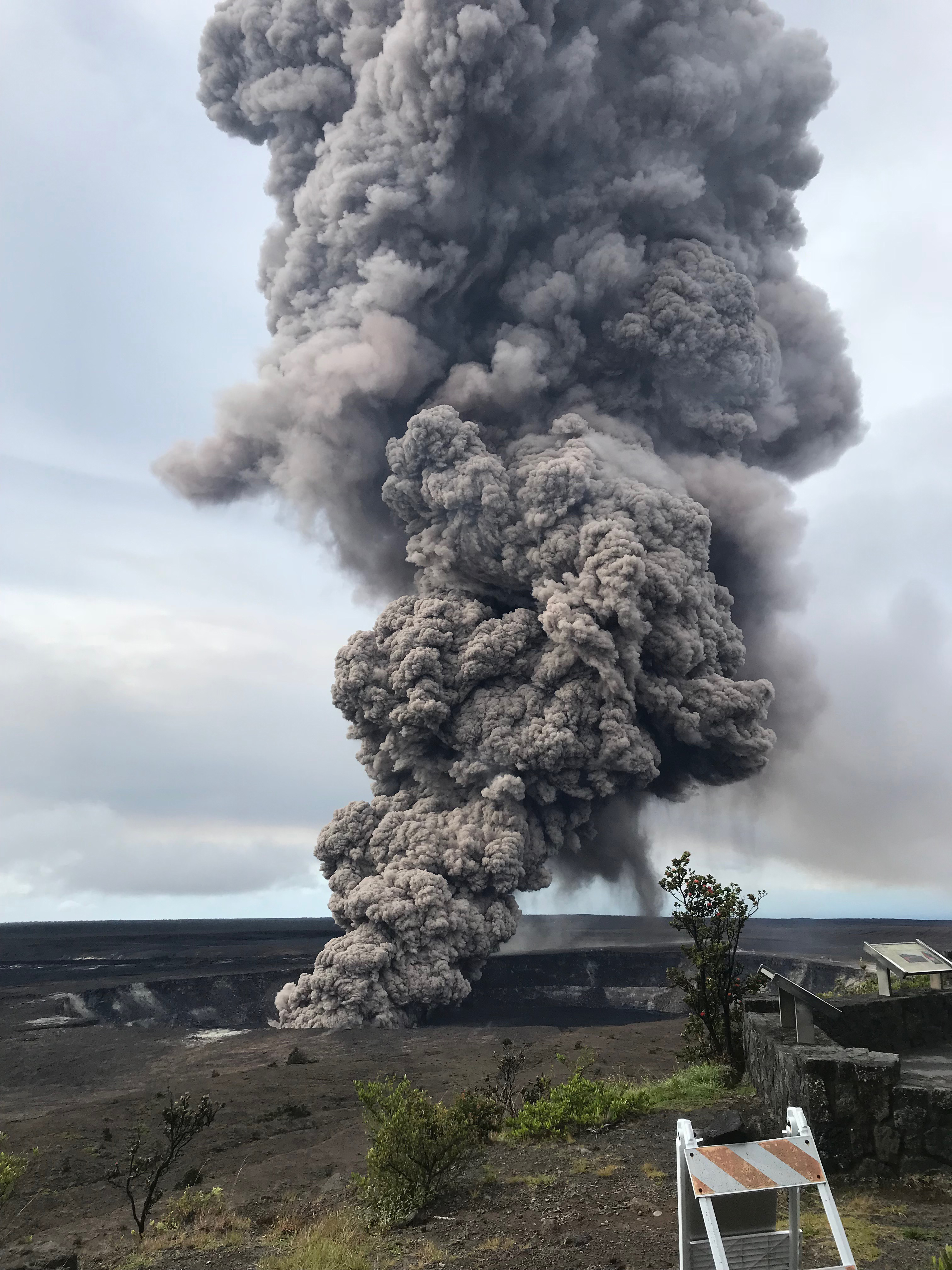
May 16: Summit Ash and Small “Ballistics”

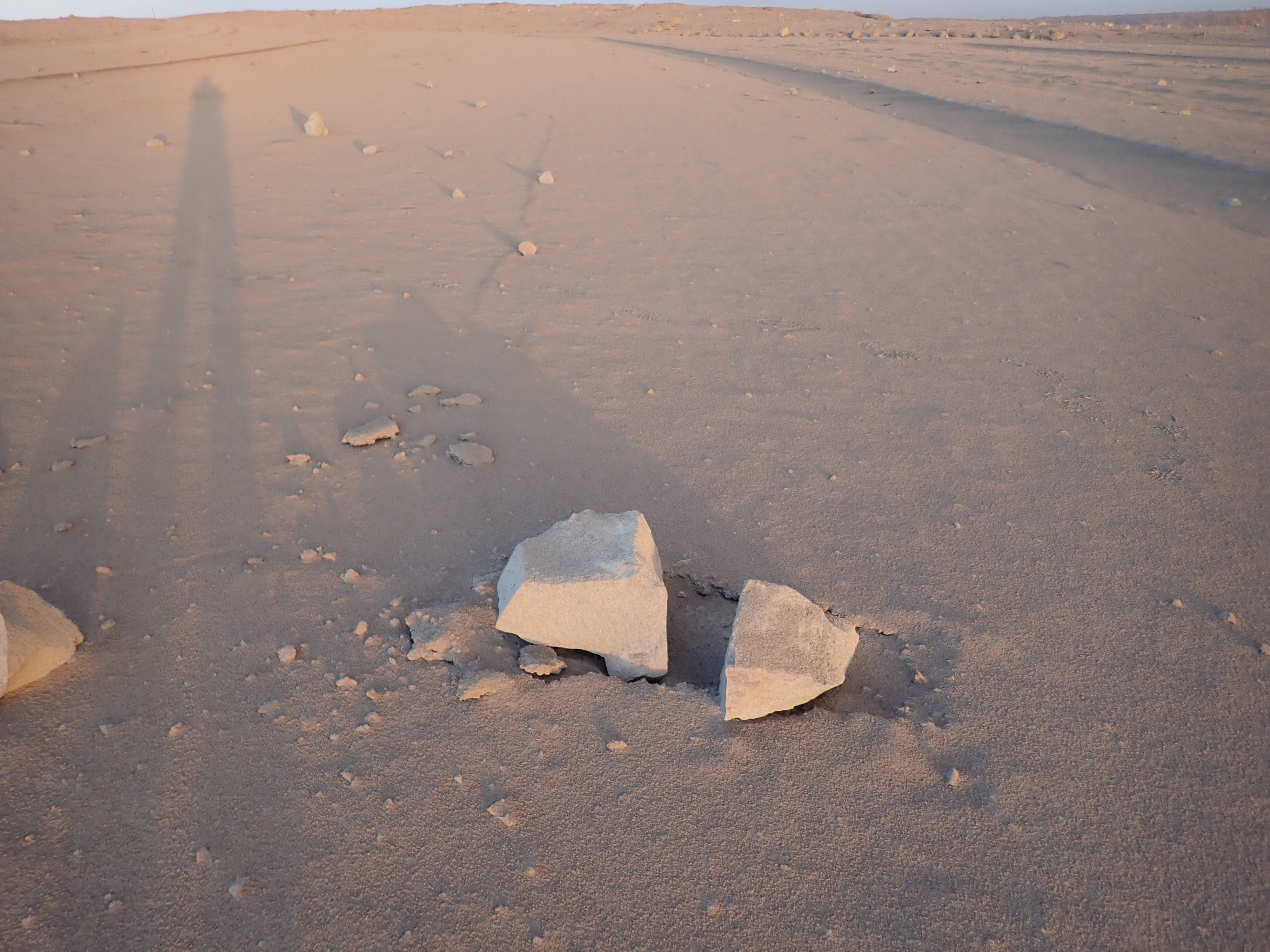
May 16, 8:36 AM, a 4.2 earthquake shook rocks from Halema’uma’u Overlook Crater’s walls that fell into the lava lake, caused an explosion, and sent (according to the USGS)  “dense ballistic blocks up to 60 cm (2 feet) across were found in the parking lot a few hundred yards from Halemaumau.”

USGS photo of “ballistic rocks” found in parking lot next to Halema’uma’u Crater, INSIDE Kilauea Caldera, morning of May 16

Here they be. They’re ballistic, in that they soar up and down like a cannonball, with the chimney above the lava lake acting sort of like a vertical cannon. But contrary to several headlines I saw, these rocks are not refrigerator-sized.

There is light ash dusting the area and turning it into a moonscape.


May 16: HVO Raises Aviation Color Code to Red

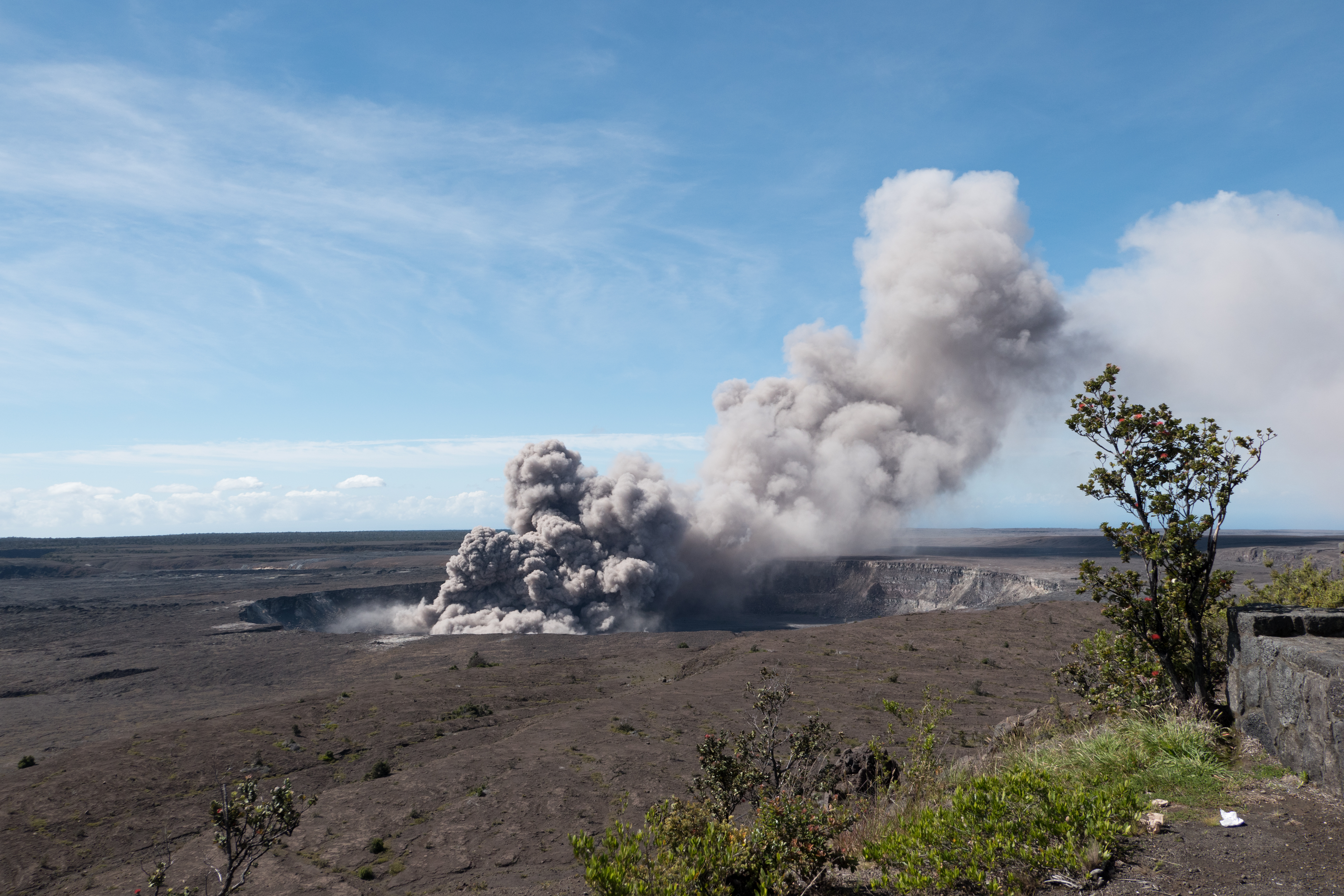
Media freaked out overnight when Hawaii Volcanoes Observatory issued a code red alert following a 12,000 foot tall ash explosion at the summit. The next morning they clarified:

USGS Volcanologist Michelle Coombs (EXCERPT):

So we’ve had some questions about what code red means. It sounds a little bit alarming, It’s really just to say that we see significant amounts of ash from this ongoing activity, and to warn aviators about that ash. It doesn’t mean that a really big eruption is imminent. it’s really just characterizing the aviation situation.


May 15: Still Not the Big One

May 15, 11:05 AM: A major ash explosion up to 12,000 feet — which HVO still guesses was caused by rockfall into the receding lava lake— prompted HVO to raise the aviation alert level to RED, warning aircraft to stay away from the summit and ash hazards.

Unfortunately, news media took this RED ALERT to be “major eruption imminent,” instead of “no more imminent than it already is, since, as a matter of fact, it’s already erupting. But it could increase activity.”

USGS Geologist @DrJanineKrippner has been playing whack-a-mole on Twitter rumors and addressed “Kilauea’s Alert Level Was Just Raised To Red – But What Does That Actually Mean?” on IFLScience, reiterating that it was mostly an aviation alert. So did volcanologist Erik Klemetti, with a good writeup of today’s steam explosions and fissure activity on his Rocky Planet blog.

May 13: Fissure 17 Starts

I’ve not covered every single fissure: see the HVO Photo/Multimedia blog, the HVO timeline, KITV, and HawaiiNewsNow for fissure-by-fissure coverage, not to mention HNN reporter Milika Lincoln’s Instagram vids and photos, and Mike Kalbers’ wonderful daily flyovers.

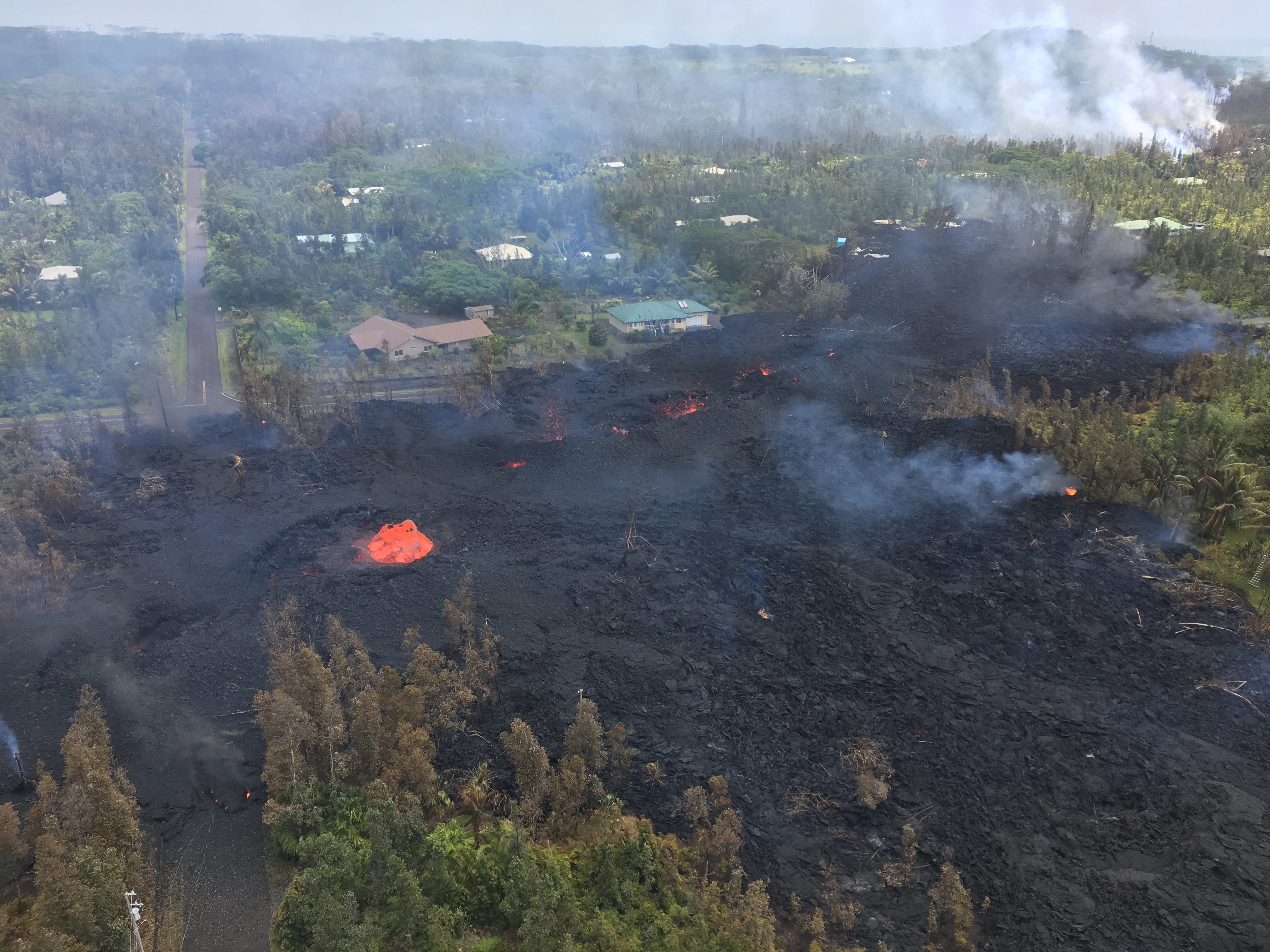
Activity ebbed and flowed, some days with more steam, some with more spatter. For the most part, lava flows didn’t go very far, and were largely sticky, clumpy, clanky a’a. But I bookmarked fissure 17 early on for particularly dramatic fountains (those blocks it’s hurling are called “lava bombs”) and incredible booms and roars:

#LeilaniEstatesEruption LATEST (May 15 at 8:30 AM): Incredible new sunrise footage captures the sounds and sight of lava fountains and gas bombs erupting from the 17th fissure — which broke out Saturday off of Halekamahina Loop Road northeast of Lanipuna Gardens on the Kalapana side of Highway 132. According to USGS HVO scientists, fissure 17 has created a narrow lava flow heading makai — or downslope toward the ocean — and has already covered about two miles. Civil Defense officials say based on their last measurement, this flow front is now a little less than a mile from Highway 137. At one point yesterday, it was moving at a rate of about 100 yards an hour, but it has since slowed a bit. The flow has been running roughly parallel to Highway 132 or Pahoa Kapoho Road. Officials say it's heading east in the direction of Kapoho toward Highway 137 — also called Old Government Beach Road, or more commonly referred to by residents as Waa Waa Road. This fissure has already claimed one structure — but officials say there are currently no homes or buildings in its current path. This has been the longest-lasting, most active fissure of the 20 that have opened up since this the first on May 3 along Mohala Street within #LeilaniEstates. Stay tuned to @HawaiiNewsNow for the very latest developments #HInews #HawaiiNews #HNN #HawaiiNewsNow #WeAreYourSource (Video: @bradah.dom / @ikaikamarzo)

A post shared by Mileka Lincoln (@milekalincoln) on

and it was the first one that really seemed to be making a run for the ocean and creating a sustained lava flow.

Here’s May 13 and 14th flyovers from Mick Kalber:

Luckily, it chose a route that doesn’t have many houses downslope. And unlike other fissures, it just kept going and going.

And (since I’m posting this backdated): it’s still going on May 19, after making quite an impressive lava fountain and cinder cone for itself over the past two nights.

May 9-10: USGS Warns of Possible Steam Explosions

Attention shifted back to the summit on May 9, when a 3.1 earthquake set off a rockfall that agitated the lava lake and sent up a 6000-foot poof of ash (video clip National Parks site):

Rockfall into Halema’uma’u lava lake sends up plume of ash, 8:27 May 9.

Rockfalls caused poofs of ash like this even back when the lava lake was full, but that was more than usual. (See also USGS video from May 7, when lava lake was still visible, showing how falling rocks agitate it).

However, that was just a teaser. The big news was the dropping lava lake…

…prompted HVO to issue its first warning about steam explosions if the lava dropped below the water table.

Hawaii Volcanoes National Park closed Friday May 11 as a precaution, since the lava lake was projected to reach the water table sometime that day. For the next few days it continued to send up a white plume of steam and/or ash clouds when rocks from the sides of the chimney fell in:

[USGS] May 11, 9:12 AM: second ash explosion
On steam (phreatic) explosions:

Continue reading May 9-10: USGS Warns of Possible Steam Explosions

May 7-9: Fissures Slow Down (For Now)

Fissures continued to open, but mostly emitted slow, sticky lava that didn’t travel far. Leilani residents continued to be allowed back during the daytime.

Video: lava flow eats Mustang (dead battery; owner left it to focus on rescuing other possessions), another flow pushes through metal gate.  These slow-moving, clumpy, clanking flows that pile up like a rocky bulldozer are “a’a” lava.

More fissure news/Videos from May 7 until 10:
  • May 7: USGS Status Report (12 fissures total by afternoon)
  • May 8: Mike Kalber video of Fissure 13 steaming, spattering
  • May 8-9: Good article from Hononulu Star-Advertiser (videos, detailed info on progress of eruption, evacuations)
  • May 8: Evening Civil Defense Update from Big Island Video News with lava footage. 14 fissures by day’s end.
  • May 9: Video – Mike Kalber flyover of fissure eruptions; today steaming, not much lava
  • May 9: Video clips – Steaming fissures sound like they’re breathing,  huff and puff
  • 15 fissures by end of May 9, cracks (but not lava) open W. of Highway 130, back up rift zone.
  • Fissure eruptions pause on May 10. Briefly.

May 5-6 Weekend: Fissures in Leilani

panorama of street intersection showing low wall of cooled lava and spatter in distance, cutting across roads and into trees
From USGS Website: “Panoramic view of fissure 7 from the intersection of Leilani and Makamae Streets in the Leilani Estates subdivision. This photo was taken at 06:01 a.m. HST today.”

Evacuated residents of Leilani Estates were allowed back on Sunday May 6 to collect vital documents, pets and possessions. New fissures  continued to open up and spatter, and officials warned about toxic sulfur dioxide gas (SO2) coming from fissures as well.

From USGS Photo/Video blog: “Bubble burst” from fissure 7, morning May 5.
WEEKEND LAVA VIDEOS, images, news, INFO:

Continue reading May 5-6 Weekend: Fissures in Leilani

May 5: Pu’u O’o, Before and After

Screencaps from Mick Kalber flyover videos April 28 and May 4(?) as noted by @ReelNewsHawaii on Twitter.

May 4: USGS Scientist Explains First 24 Hours of Eruption

HVO Scientist-in-Charge Tina Neal gave an EXCELLENT evening briefing on the first 24 hours of the Leilani Estates Eruption, explaining very clearly what was happening and why.

[Big Island Video News, overlaid with video from Mick Kalber flyover]

Powerpoint slide summary of TALK:
  • 6 fissures in first 24 hours — more are expected
  • No lava flows extending more than tens of yards so far — flows are expected
  • Magma intrusion into LERZ [Lower East Rift Zone] is continuing
  • High levels of sulfur dioxide gas [SO2] near fissures and downwind
  • More Magnitude 5+ earthquakes possible as volcano adjusts to intrusion
Excerpts from this Briefing:

Continue reading May 4: USGS Scientist Explains First 24 Hours of Eruption