Here’s a transcript of this week’s presentation from HVO Deputy-Scientist-in-Charge Steve Brantley at the Tuesday Pahoa Community Meeting.
I’m going to start with a broad overview of the eruption so far. We’re 80 days into the eruption [since the floor dropped on Puʻu ʻŌʻō, I think] about now, so I want to provide a little bit of context, in terms of similar activity or un-similar activity in the past 200 years. And then we’ll do a quick summary of what’s happened in the past week.
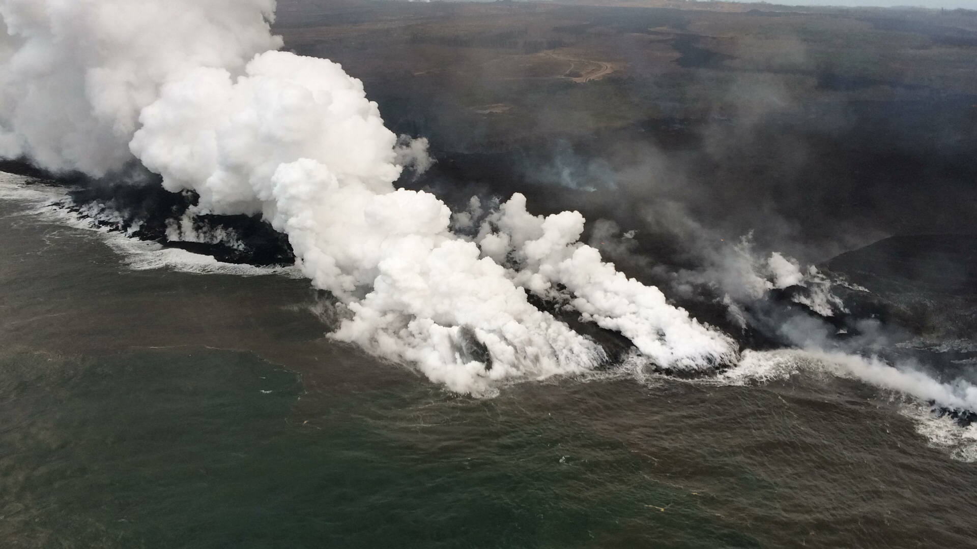
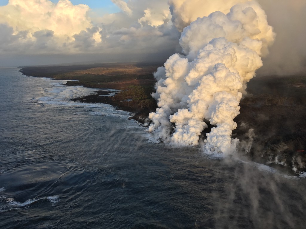
July 16, 2018. USGS: “The active ocean entry along the southernmost margin of the fissure 8 flow is a hazardous area. The interaction of lava and seawater creates “laze,” a corrosive steam plume laced with hydrochloric acid and fine volcanic glass particles that is blown downwind and can irritate the skin, eyes, and lungs. Lava flows entering the ocean can also result in explosive interactions, littoral explosions, that can hurl fragments of molten lava and rocky debris hundreds of meters (yards) inland and seaward.” (Full-sized)
Today’s Eruption Summary
The big news today was a lava tour boat getting pelted by lava chunks from an ocean entry explosion, resulting in burns, bruises, and one broken leg. Next to that, the science of this eruption seems a bit trivial. But this blog is primarily oriented towards the latter, so let’s get volcanology news out of the way first.
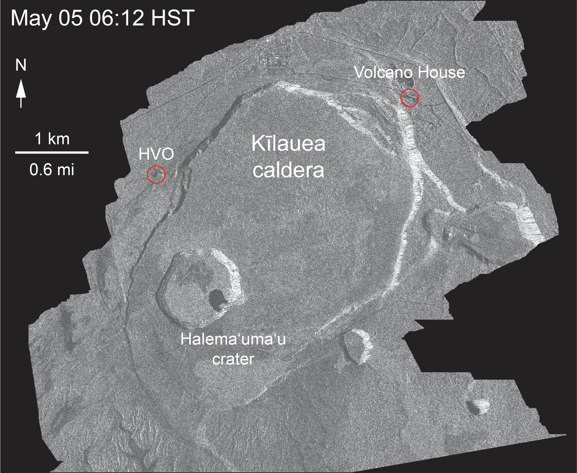
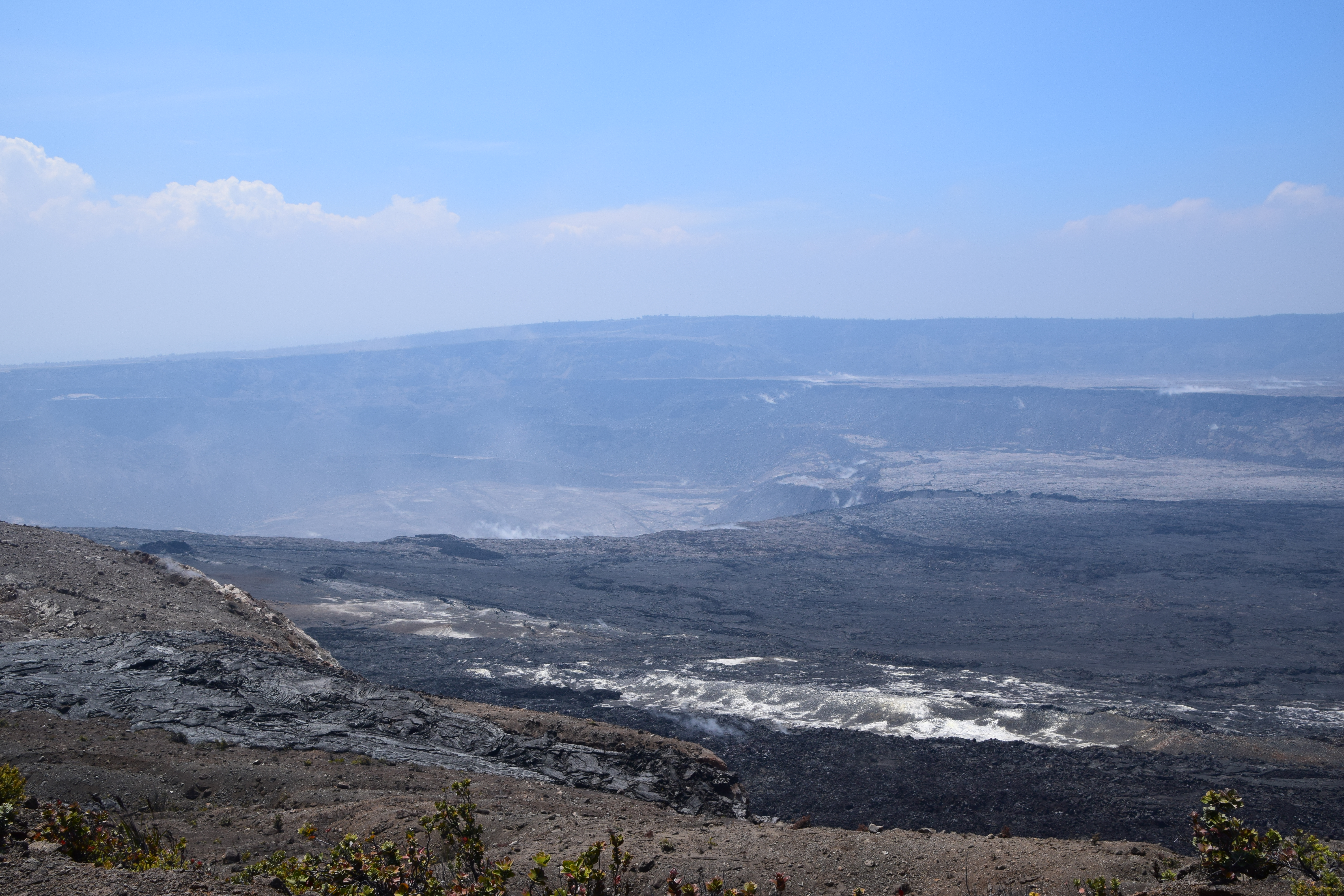
The Italian Space Agency released a new CosmoSkyMed radar scan of Kīlauea’s summit. Let’s hope this really is the new northern extent of Halemaʻumaʻu:
May 5-July 16, 2018. USGS: “Over time, expansion of the summit eruptive vent within Halema‘uma‘u crater and the widening of Halema‘uma‘u itself are obvious. Starting in late May, the development of several cracks outside Halema‘uma‘u is clear, and inward slumping of a large portion of the western, southwestern, and northern crater rim begins. Much of this motion appears to be coincident with the small explosions from the summit that have taken place on a near daily basis since early June. The most recent radar scene, from July 16, shows continued motion along cracks over a broader area of the caldera floor, extending east of Halema‘uma‘u. We expect this slumping to continue as long as the collapse events and overall subsidence persist.” (Full-sized)
This morning, over 24 hours after the previous summit collapse, the lava channel below Fissure 8 was full but not overflowing. Even after today’s 11:42am summit collapse, there was no observed surge— “Nothing notable in the way of overflows.” Last night’s field crews heard Fissure 22 grumbling to itself, but saw no visible signs of renewed activity.
According to Civil Defense this afternoon, the southern edge of the main lava flow has stalled 1 km from Isaac Hale Park / Pohoiki boat ramp. Just north of there, the new ocean entry at Ahalanui is vigorous and dangerous. That’s where @hotseathawaii filmed an offshore explosion four days ago. There were more explosions this morning, “with at least one being quite strong” (USGS).
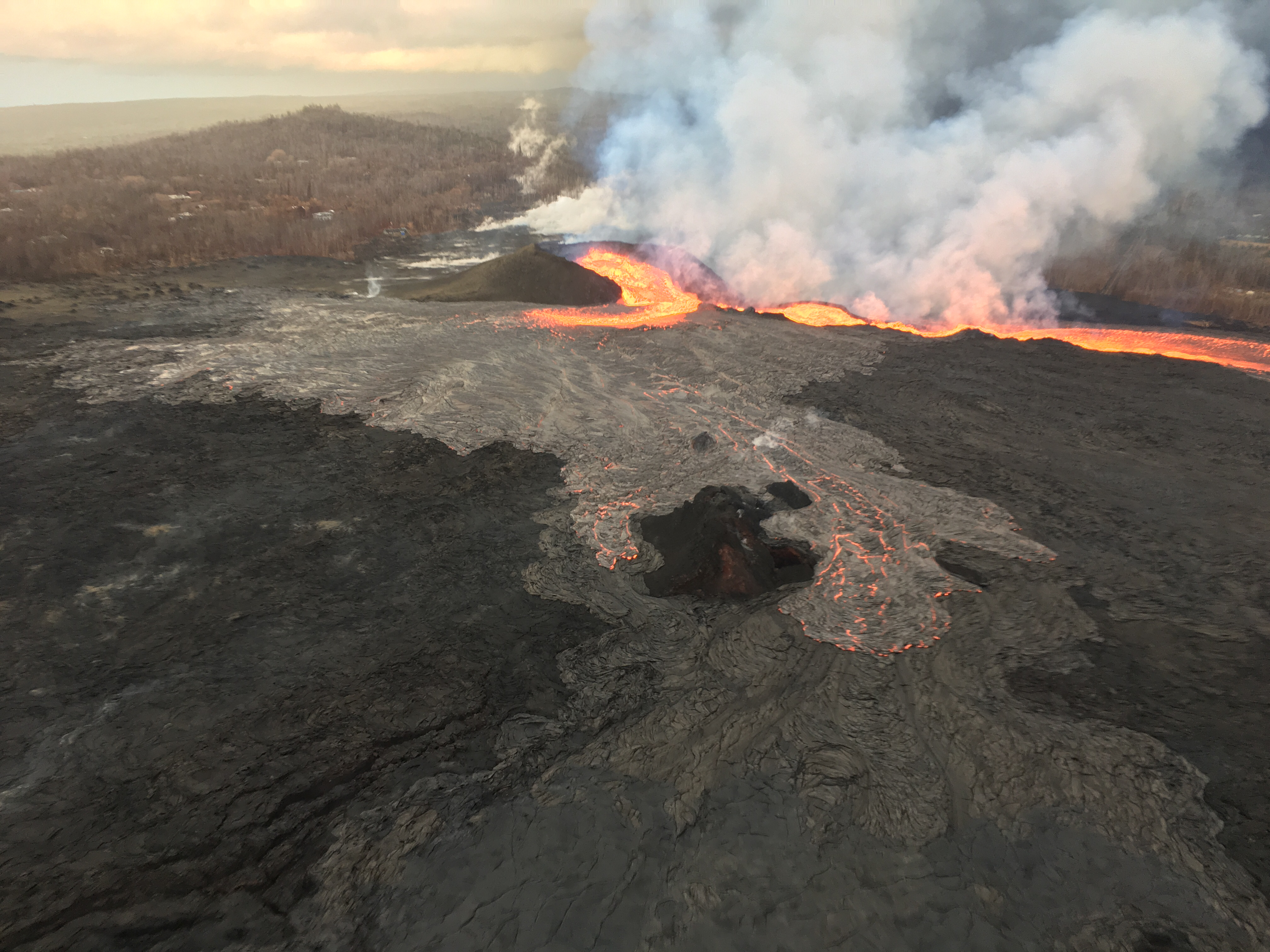
July 15, 2018. USGS: ” View of fissure 8 looking uprift toward the west. The open lava channel in upper right leads to the ocean; when the photo was taken this early morning, nearly all of the lava erupting from fissure 8 was in the channel. Some lava was spilling eastward to form a slowly advancing flow (middle foreground) atop earlier lava flows. This flow stalled within hours.” (Full-sized)
Today’s Eruption Summary
Kilauea’s double eruption continues as usual. Fissure 8’s lava river is still sending lava mostly to the southern ocean entry near Ahalanui, following the diverted channel on the west side of Kapoho Crater. The southern margin of the lava flow along the coast has slowed its southward advance, possibly giving Pohoiki/Isaac Hale Park a respite. At 7pm HST, HVO said it was “around half a mile away.”
July 15, 2018. USGS: ” Laze plume rises where lava pours into the sea on the south margin of the fissure 8 flow. This southern boundary did not change location appreciably in the past day, remaining about 900 m (0.56 mi) from the boat ramp at Isaac Hale Park.” (Full-sized)
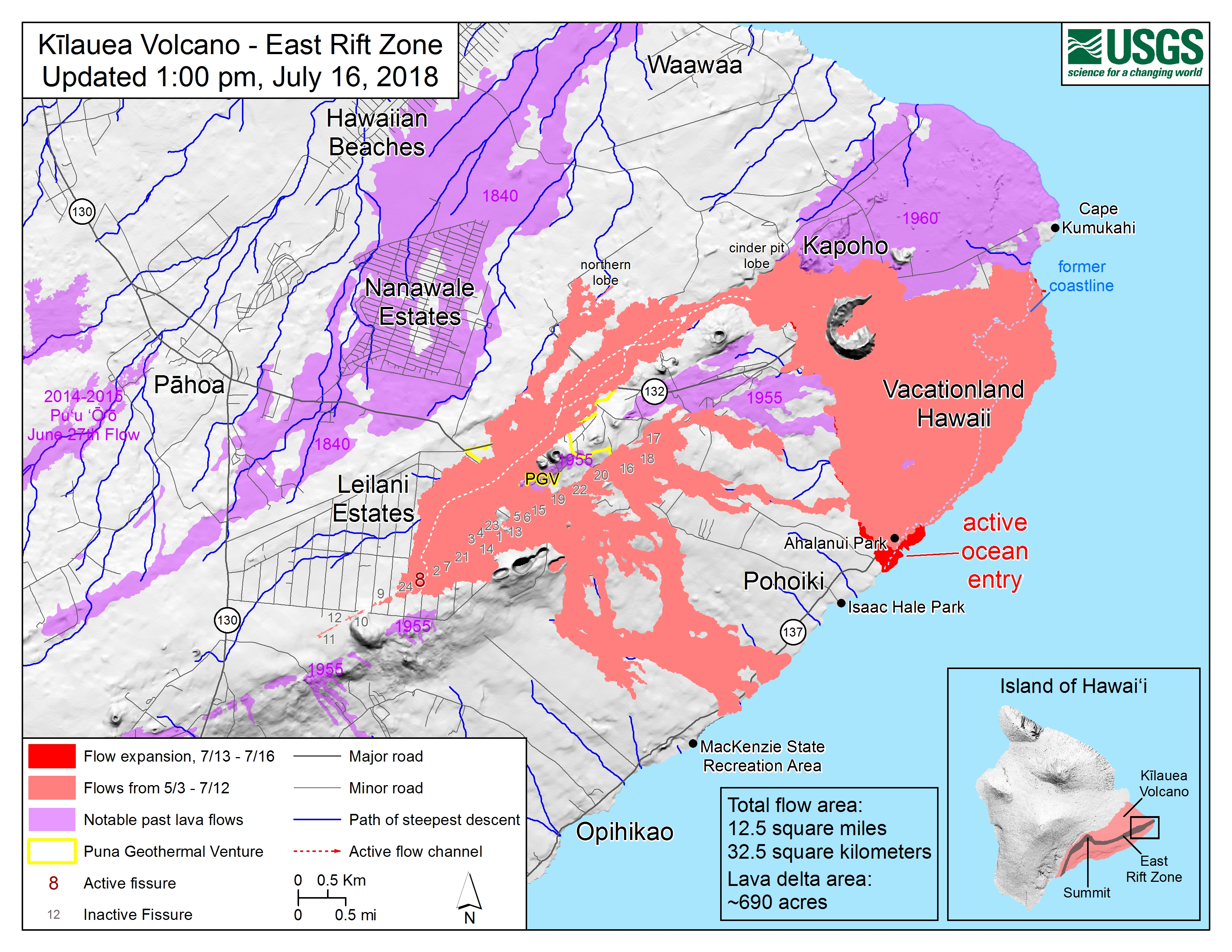
The tiny island that formed Friday is now a tiny peninsula, joined to shore by a neck of lava or possibly just black sand. Lava continues to ooze into the ocean here and there along the broad front of 6 km (3.7mi) lava delta. Recent HVO Kilauea status alerts have warned that this delta has built out 0.5 miles from the former coastline, and is resting on “unconsolidated lava fragments and sand,” which can give way.
Following this morning’s 3:26 am collapse event (M5.2) at Kilauea’s summit, a pulse of lava came down the rift zone to Fissure 8. This caused an early-morning, temporary overflow to the ESE which did not extend beyond the boundaries of earlier flows. (This spillover was very visible during a 6:30am @hotseathawaii livestream overflight). No other vents show any activity.
USGS: “View of Halema‘uma‘u taken today (July 15) from the south side of the caldera near the KEANAKEKOI Overlook.” (Full-sized)
Sadly, yesterday afternoon was the end of Kua O Ka La Charter School and Ahalanui Warm Ponds. The flow that diverted west of Kapoho Crater created a channelized a’a flow all the way to the ocean. There is now a strong ocean entry at what used to be Ahalanui Beach Park. There are still multiple “ooze-outs” along the northern lava flow front spanning former Kapoho Bay— it’s now 6 km, 3.7 miles across— “despite no visible surface connection to the fissure 8 channel.”
[Below: USGS 6am overflight, July 12: Fissure 8 perched lava channel, new diverted channel around Kapoho Crater, Ahalanui ocean entry.]
Speaking of the ocean entry, Bruce Omori of @HotSeatHawaii captured a startling offshore laze/steam/lava explosion just offshore:
Huge underwater explosion from Hawaii eruption. Bruce & Mick don't quite see it and I think the explanation for that is that the GoPro shoots such a wide angle that even though it looks like it is right in front of them, it was likely below their line of sight. pic.twitter.com/otJxmh9TAg
Mike Zoellner, geologist, Center for the Study of Active Volcanoes, UHI
Transcript – July 11 Eruption Update
Janet Babb, USGS: On the Lower East Rift Zone, Fissure 8 continues to erupt, and overnight the channelized flow that was diverted from the main channel that went west of Kapoho Crater advanced to the ocean, and, unfortunately, in its path, it destroyed the Kua O Ko La Charter School and the Ahalanui Beach Park area. And there’s now a new, very robust ocean entry plume near the Ahalanui Beach Park area. So in all, the flow front at the ocean now is about 3.7 miles wide.
In this morning’s overflight, there were no other fissures that appeared to be active.
At the summit, following yesterday’s early morning collapse/explosion that released energy equivalent to a magnitude 5.3 earthquake, the earthquakes have resumed— there was a period of quiet, but the earthquakes have resumed and currently the summit area is experiencing about 25-30 earthquakes per hour. This pattern is expected to continue.
As far as gas emissions at the summit, the gas emissions remain low, and on the Lower East Rift Zone, the gas emissions remain high. And with that, of course, the problems with vog continue with those high emissions.
Informing the public without panicking them about an extremely unlikely but life-threatening hazard is tricky. So it’s taken the USGS a while to release this document which they’ve been promising the residents of Volcano:
This was the chief topic of Thursday’s Volcano Village meeting, led not by the National Park Service this time, but by Civil Defense Administrator Tal Magno.
Here’s the FULL video of the meeting. BigIslandVideoNews excerpted the most important part, HVO Scientist-in-Charge Tina Neal’s 4-minute talk: