[Note: this is when the overflows around Kapoho Crater got started, but the main flow front/ocean entry was still mostly north.]
I was hoping NLTV would post a video of last Tuesday evening’s Pahoa Community meeting as they usually do, since BigIslandVideoNews records Steve Brantley’s slideshows by pointing the camera at him and skipping most of the slides, but no such luck.
BIVN posted various excerpts of the meeting, including these non-geology segments: Live poll, Hwy 130 Reopening Discussed, Residents question Civil Defense.
Here’s Steve Brantley’s USGS presentation:
Transcript
Steve Brantley, Deputy Scientist-in-Charge of HVO:
Good evening, everybody. So here we are, two months into the eruption in the Lower East Rift Zone of Kilauea Volcano. I… to be honest, I’m very surprised the eruption’s still going on, personally. It has been an enormous effect on the Lower East Rift Zone, and the whole community, and the whole island. Tonight my comments are pretty restricted. There is not much new to share with you.
There has been essentially no change in the eruption rate here in the Lower East Rift Zone. We have no signs that things are slowing down here, and the same is true for the summit. The summit area continues to collapse at about the same rate. We tend to have a small…or pretty significant collapse/explosion event once a day. Varies in length from 20-30 hours or so.

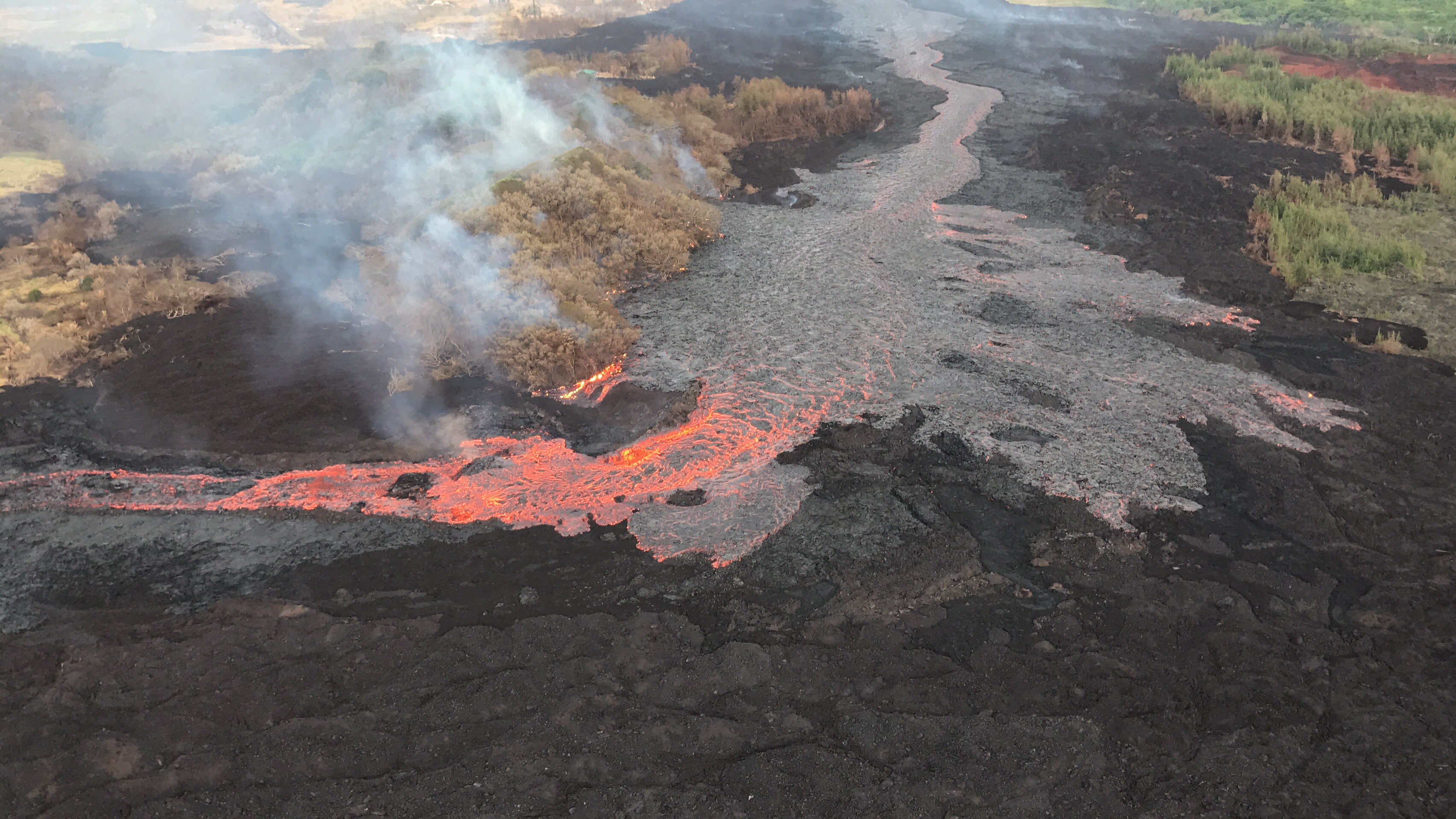
Just a quick shot here of Fissure 8. It continues to erupt a high volume of lava. The channel coming out of the Fissure 8 has tubed over on the north side, just a little bit. Can’t really see it in this image. But it’s a little section right through here [I think it’s the dark patch to the right of the upper curve of the S-bend] but otherwise the channel is still moving very, very quickly. And for the most part, in the upper part of the channel for the upper couple of miles, the lava’s been contained within the channel.
There have been a few overflows in the past week, just as in previous weeks, but nothing significant that has gone beyond the outer edge of the original flow boundary, and we’ve not observed any new seeps occurring along the north edge of that channel.

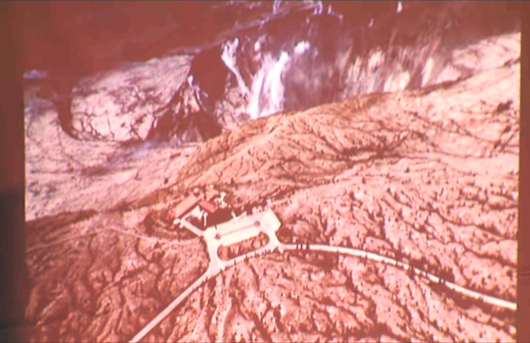
Okay, it’s a little hard to see again. There was a bit of an overflow down by Kapoho Cone, just before or just as the lava channel makes that right-hand turn to the south. The overflows are right here. [I think there was another slide here; I’m just guessing based on the audio.] Here’s the channel looking toward the ocean. So there’s been a bit spillovers here. And this spillover, this overflows happen when a big sort of island that was in the middle of the channel broke loose and kind of got wedged in across the channel, and so it sort of backed up and then spilled over.
And so that’s a pretty common process that we can expect to see again. And likewise, on the upper part of the channel, if the cone itself starts to fail, or one sector fails and a big chunk starts sliding down that channel, it could also cause a little bit of constriction which may lead to more overflows for a period of time.
The ocean entry is still quite active, obviously. Lava’s coming out of Fissure 8; it’s pretty much all going into the ocean. The lava channel is covered over about a half a mile upslope from the edge. The new lava is focused pretty much on the northern side. It looks like most of the lava is entering the ocean on the northern side, but as you can see in this image, it’s pretty much spread out over the entire lava delta. We’re up to about 555 acres of new land added to the island.
And I have a few maps to show you. I showed you these last week, and then I have one new addition at the very end, so we can see how the lava delta moved to the south, which was of a concern last week.

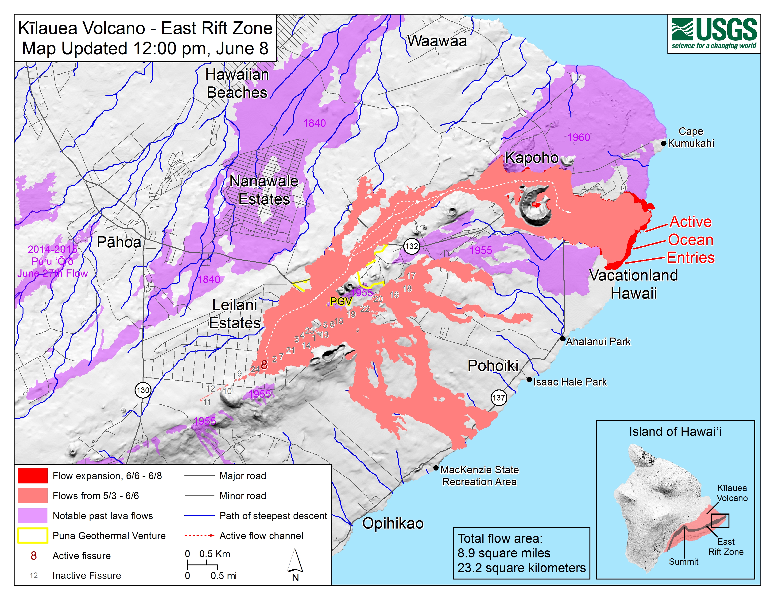
So the date is up in the upper righthand corner, so, June 8, and watch this area down here [laserpointer indicates southern “Active Ocean Entries” and “Vacationland” are on map] as we go to June 15.

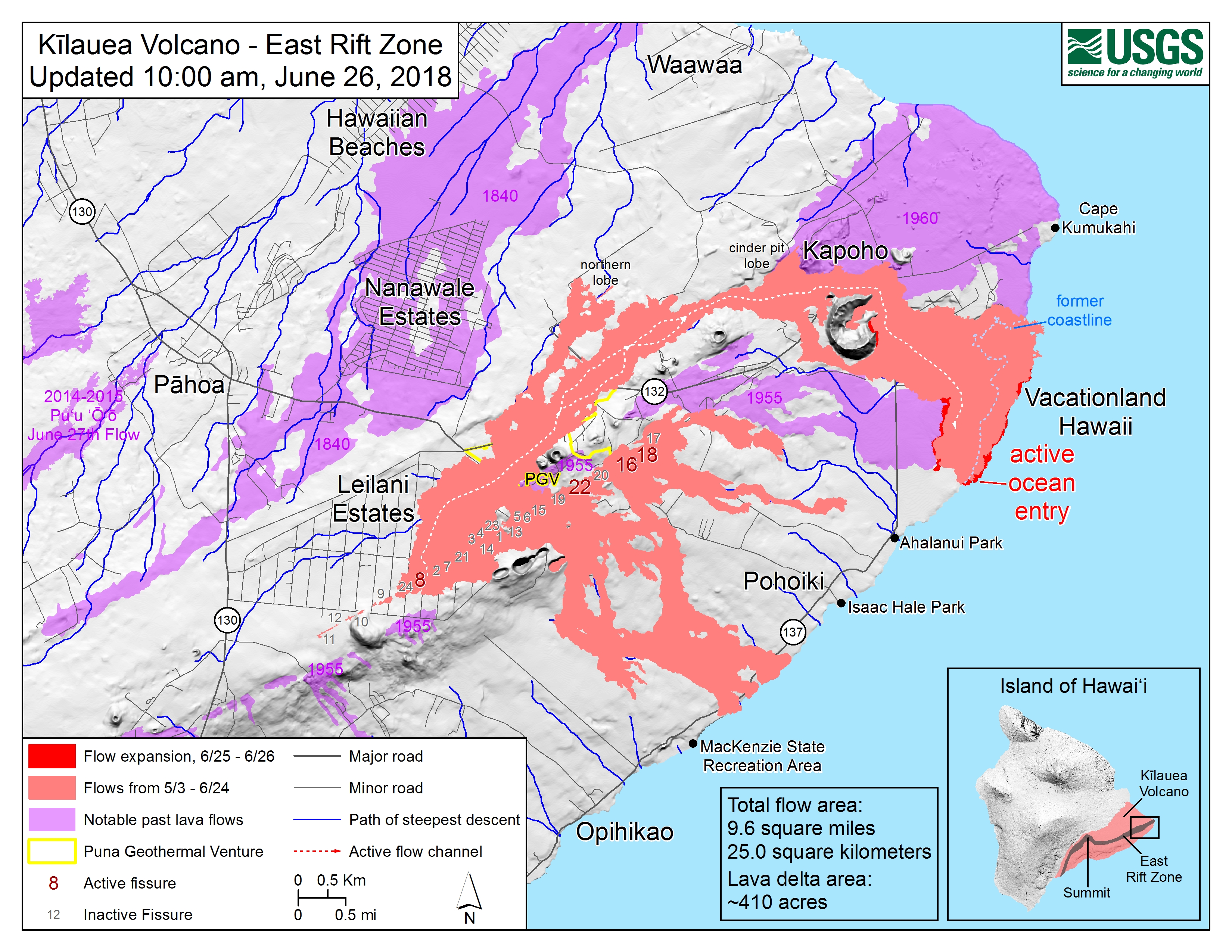
June 26.

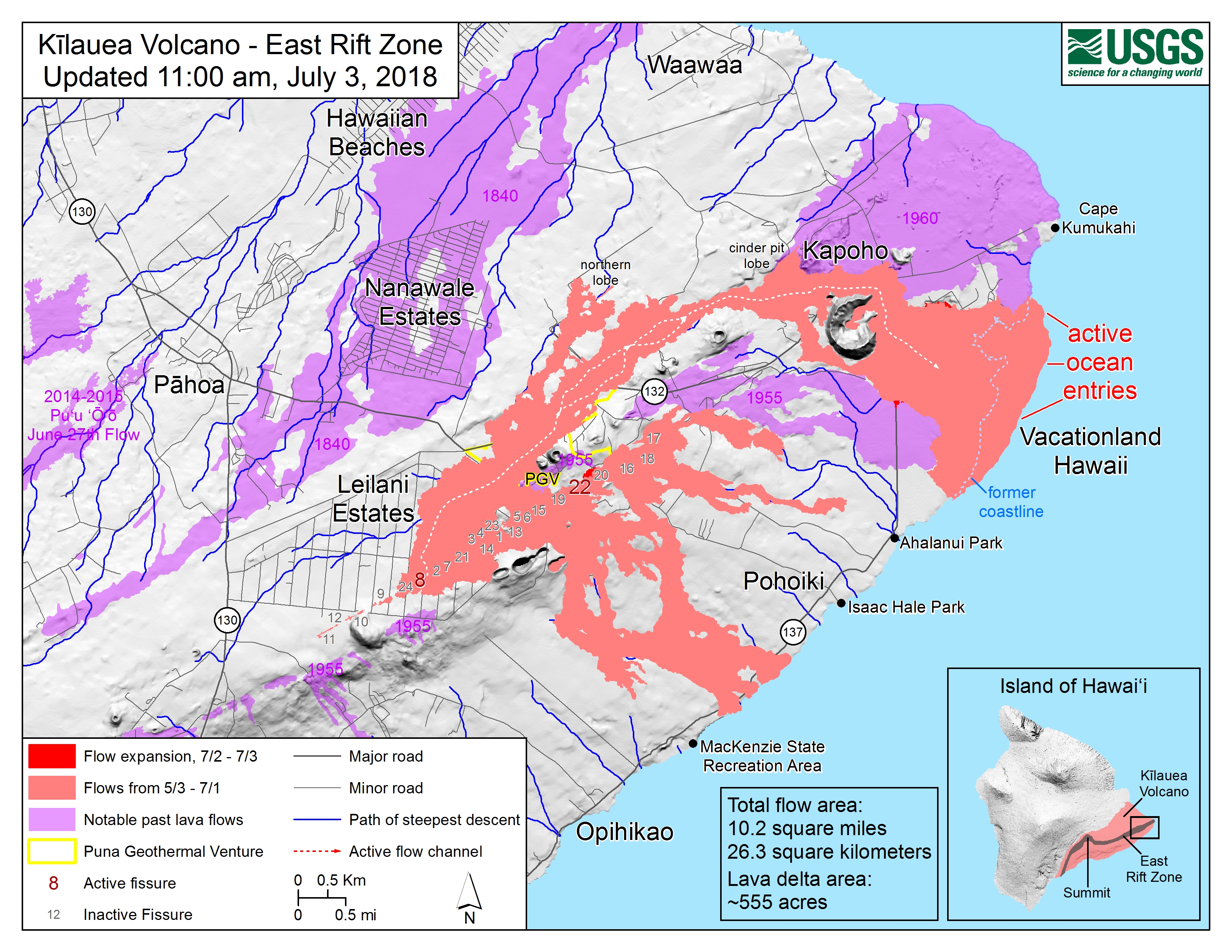
And then July 3, as of mapped of the past 24 hours.

You notice that that right-hand edge on the red showing you the new flow [indicates straight edge connecting shore NE of Ahalanui Park to purple area of 1955 flow], it’s a very— it looks like a straight edge. That’s kind of weird, when you see that. You’ll [go] “What’s going on there to have such a straight edge?” And it looks like that flow boundary is butting up against some older a’a flow that’s a few hundred years old. It’s not entirely clear because the laze plume is blowing over that area almost all of the time. So it’s really hard for us to see exactly what’s occurring there and exactly how far the lava’s moved to the south.
And my final slide— this is photograph taken today showing you the observatory and Jaggar Museum inside the Hawaii Volcanoes National Park right in the center, and the large and growing Halema’uma’u Crater in the background.
Hard to point out features there because it’s so dark. I apologize for that. But the crater continues to enlarge as flanks of the crater walls slough into the main core of the crater. And it is now pulling in parts of the crater [caldera] floor about halfway across the entire Kilauea caldera floor. And so that’s just a consequence, again, of rock material falling into the Halema’uma’u void that is left as magma drains out of the magma reservoir and moves into the rift zone.
Often people wonder how long will this continue? How much further can the crater collapse? And it can continue to collapse a lot. When people— when westerners, I should say— when westerners first arrived about 200 years ago and peered over the edge, most of the crater floor was very, very deep, as deep as 1500 to 1700 feet in the deepest parts. So there can be just in the past 200 years, we have an example that the crater can get very very deep.
So for the folks up at the summit, that means more earthquakes. Most of them are magnitude 2s you don’t feel, but the 3s and 4s and then the 5s, of course, are felt quite widely up there. And that will likely continue to occur as magma’s withdrawn from the summit reservoirs and moving into the rift zone. Thank you.