May 9-10: USGS Warns of Possible Steam Explosions

Attention shifted back to the summit on May 9, when a 3.1 earthquake set off a rockfall that agitated the lava lake and sent up a 6000-foot poof of ash (video clip National Parks site):

Rockfall into Halema’uma’u lava lake sends up plume of ash, 8:27 May 9.

Rockfalls caused poofs of ash like this even back when the lava lake was full, but that was more than usual. (See also USGS video from May 7, when lava lake was still visible, showing how falling rocks agitate it).

However, that was just a teaser. The big news was the dropping lava lake…

…prompted HVO to issue its first warning about steam explosions if the lava dropped below the water table.

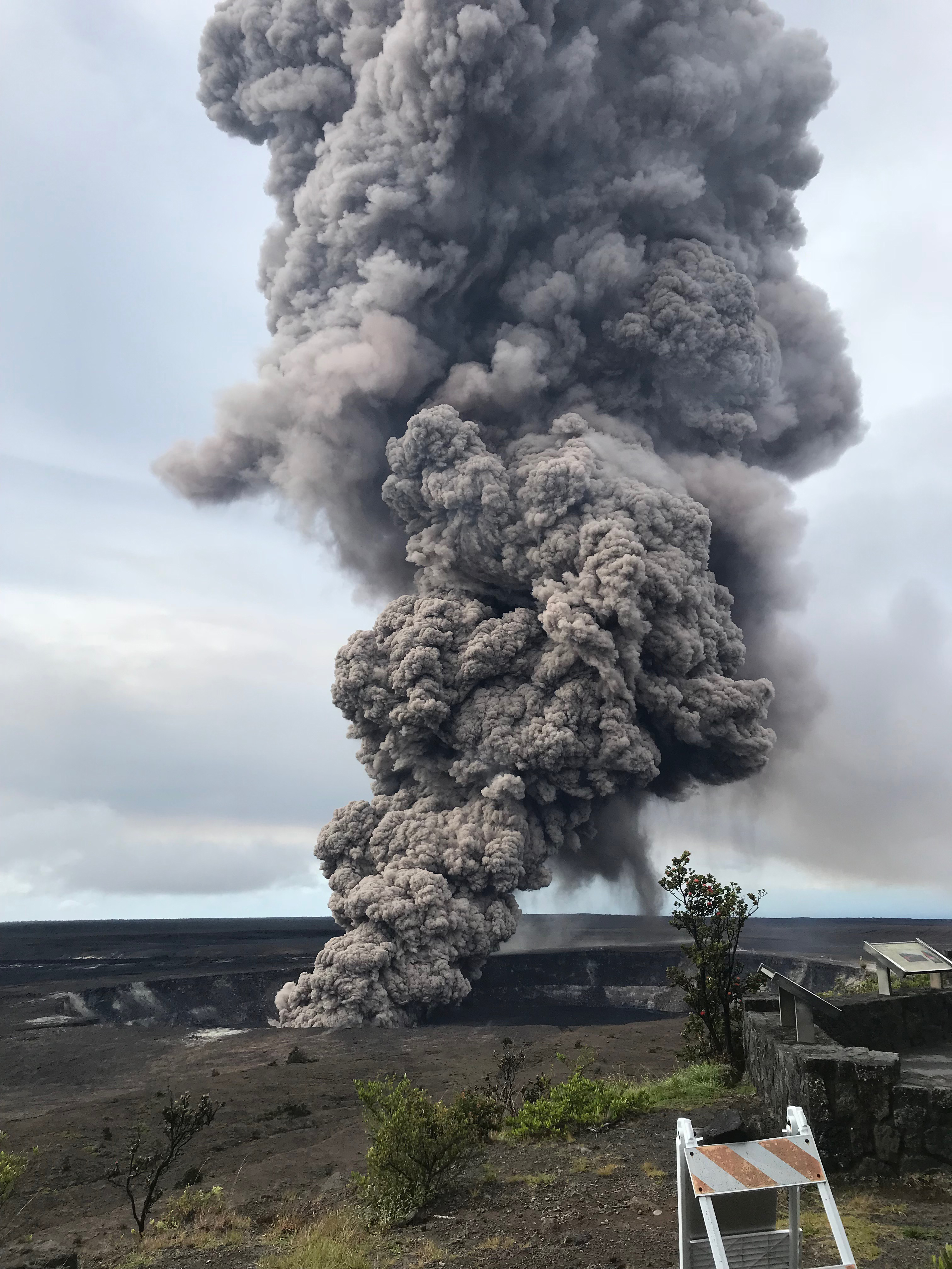
Hawaii Volcanoes National Park closed Friday May 11 as a precaution, since the lava lake was projected to reach the water table sometime that day. For the next few days it continued to send up a white plume of steam and/or ash clouds when rocks from the sides of the chimney fell in:

[USGS] May 11, 9:12 AM: second ash explosion
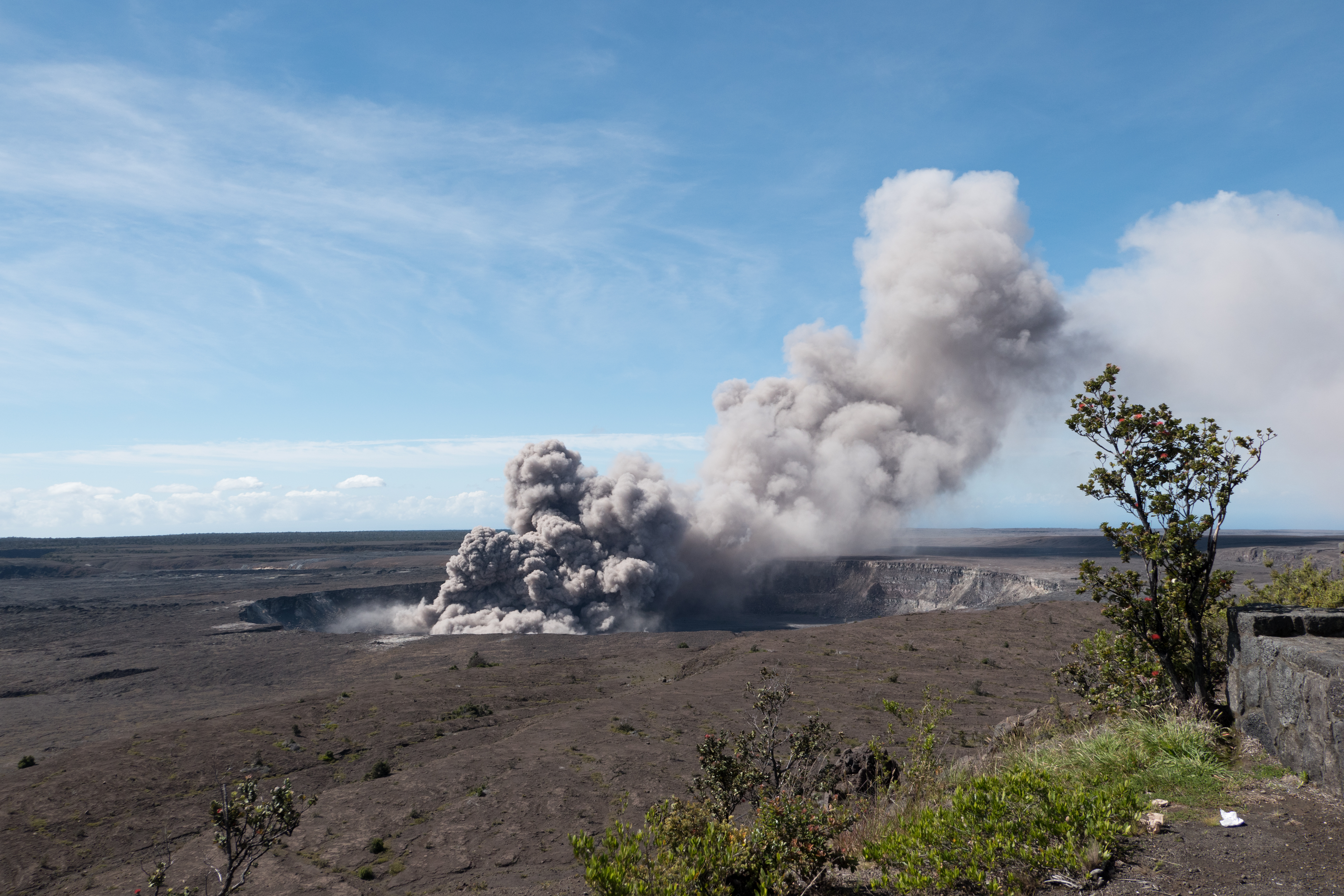
On steam (phreatic) explosions:

Continue reading May 9-10: USGS Warns of Possible Steam Explosions

April 30: Halema’uma’u Lava Lake Before It Dropped

Amateur video of Halema’uma’u lava lake in Overlook Crater, taken by Jeffrey Brown on April 30, 2018.

The week before, the summit had been inflating and the lava lake had been overflowing, as seen on this USGS timelapse video of Halema’uma’u Crater April 25-26.

Map of Halema’uma’u and Kilauea Summit, because it’s a little confusing:

Continue reading April 30: Halema’uma’u Lava Lake Before It Dropped

End of April: Halema’uma’u Lava Lake Overflows

Halema’uma’u a few days before eruption started…

April 22: USGS Handheld Video of Lava Lake

Excellent overview of lava lake, back wall and crater floor of Halema’uma’u. Shot from crater rim at Halema’uma’u overlook.

USGS: “This video shows an overview of the lake from the Halema‘uma‘u Crater rim, as well as some of the spattering that was occurring on the lake margin on Sunday, April 22.”

Apirl 25: USGS Handheld Video of Lava Lake

You can see how much it overflowed in just 3 days. Taken from crater rim, Halema’uma’u overlook.

USGS: “On Kīlauea Volcano’s summit, the Halema‘uma‘u lava lake’s high standing lake level produced intermittent overflows onto the crater floor. Smaller overflows and spattering have started to build a few discontinuous levees and a spatter cone around the lake margin, shown in these video clips taken from the lakes north and northeastern margin.

April 26: USGS Helicopter Overflight

USGS: “Vigorous overflows from Kīlauea’s summit lava lake covered a large portion of the floor of Halema‘uma‘u this morning. In this video, the view starts from the north and heads south, showing the north and east sides of Halema‘uma‘u crater. During the overflight, a large overflow was active on the north margin of the lava lake, sending a cascade of lava down the elevated lake rim.”

April 25-27 Timelapse From HVO Webcam

USGS: “This time-lapse video from 7:30 p.m. April 25 to 7:30 p.m. April 26 shows Halema‘uma‘u lava lake producing intermittent overflows onto the crater floor. The largest of these flows was from approximately 6:15 a.m. to 10:30 a.m. on April 26 and covered about 90 acres (2/3) of the crater floor.”


April 13, 2018: Halema’uma’u Before Everything Changed

[Backdated post] I keep needing to refer back to this April 13, 2018 USGS photo of the summit of Kīlauea and Halemaʻumaʻu Crater before everything changed.

Kilauea summit, April 13, 2018. Original caption on HVO Photo & Video Chronology page: “At the summit of Kīlauea Volcano, the gas plume produced by the Halema‘uma‘u lava lake was blown to the southwest by normal trade wind conditions today. The lake level has been relatively high over the past several weeks and intermittently visible from the Hawai‘i Volcanoes National Park Jaggar Museum Overlook. The museum and HVO are perched on the caldera rim (middle right), with the slopes of Mauna Loa visible in the background.” (Full-sized)

March 19, 2018: Ten Year Anniversary of Lava Lake in Halema’uma’u Crater

Today marked the ten-year anniversary of the opening of the “Overlook Vent” lava lake within Halemaʻumaʻu Crater at the summit of Kīlauea Volcano.

2008 and 2018 views of the “Overlook vent” lava lake within Halema’uma’u Crater.

From March 19 post of HVO’s Photo & Video Chronology archive:

Today marks the 10th anniversary of the eruption within Halema‘uma‘u at the summit of Kīlauea Volcano. When thevent first opened on March 19, 2008, it formed a small pit about 115 feet (35 m) wide. Over the past decade, that pit (informally called the “Overlook crater”) has grown into a gaping hole about 919 feet by 656 feet (280 x 200 m) in size. Click on the above webcam images to watch the growth of Overlook crater over the past 10 years.

That post also shared a slideshow of the lava lake’s formation and widening over a ten-year period:

Timelapses of Kīlauea Summit, Week of March 19

These were taken from HVO’s webcams, which at the time had been capturing images of the caldera and lava lake (“Overlook Vent”) every ten minutes for years. They give you a sense of what “normal” was for Kīlauea prior to the start of this eruption:

Views into the lava lake from two webcams that were some of the first casualties of this eruption:

At the time, there was no summit livestream.  Webcams were plenty to keep up with the day-to-day fluctuations.

USGS Video: History of Lava Lake (20 minutes)

Dr. Matt Patrick (USGS) reviews the ten year history of the overlook vent lava lake. Around 8:55 the camera pans around to show the entire lake and other parts of Halemaʻumaʻu Crater. These are some of the last views of it prior to changes in May 2018.

Wind noise makes him a little hard to hear. The USGS also posted this video on their own multimedia library. Since their server sometimes times out, let me include the transcript below.

Continue reading March 19, 2018: Ten Year Anniversary of Lava Lake in Halema’uma’u Crater

Oct 2017: Lava Lake at Kilauea’s Summit, Nine Years On

Excellent retrospective the USGS put out in 2017 on the then nine-year-old lava lake at Kilauea’s summit, with great information and spectacular views:

USGS video description:

In March 2008, a new volcanic vent opened within Halema‘uma‘u, a crater at the summit of Kīlauea Volcano in Hawaiʻi Volcanoes National Park on the Island of Hawaiʻi. This new vent is one of two ongoing eruptions on the volcano. The other is on Kīlauea’s East Rift Zone, where vents have been erupting nearly nonstop since 1983. The duration of these simultaneous summit and rift zone eruptions on Kīlauea is unmatched in at least 200 years.

Since 2008, Kīlauea’s summit eruption has consisted of continuous degassing, occasional explosive events, and an active, circulating lava lake. Because of ongoing volcanic hazards associated with the summit vent, including the emission of high levels of sulfur dioxide gas and fragments of hot lava and rock explosively hurled onto the crater rim, the area around Halemaʻumaʻu remains closed to the public as of 2017.

Through historical photos of past Halemaʻumaʻu eruptions and stunning 4K imagery of the current eruption, this 24-minute program tells the story of Kīlauea Volcano’s summit lava lake—now one of the two largest lava lakes in the world. It begins with a Hawaiian chant that expresses traditional observations of a bubbling lava lake and reflects the connections between science and culture that continue on Kīlauea today.

The video briefly recounts the eruptive history of Halemaʻumaʻu and describes the formation and continued growth of the current summit vent and lava lake. It features USGS Hawaiian Volcano Observatory scientists sharing their insights on the summit eruption—how they monitor the lava lake, how and why the lake level rises and falls, why explosive events occur, the connection between Kīlauea’s ongoing summit and East Rift Zone eruptions, and the impacts of the summit eruption on the Island of Hawaiʻi and beyond.

Additional Credits:
Producers: Janet Babb and Steve Wessells
Writers: Janet Babb, Donna Matrazzo, and Steve Wessells
Director of Photography: Richard Lyons”

Continue reading Oct 2017: Lava Lake at Kilauea’s Summit, Nine Years On