Today’s Eruption Summary
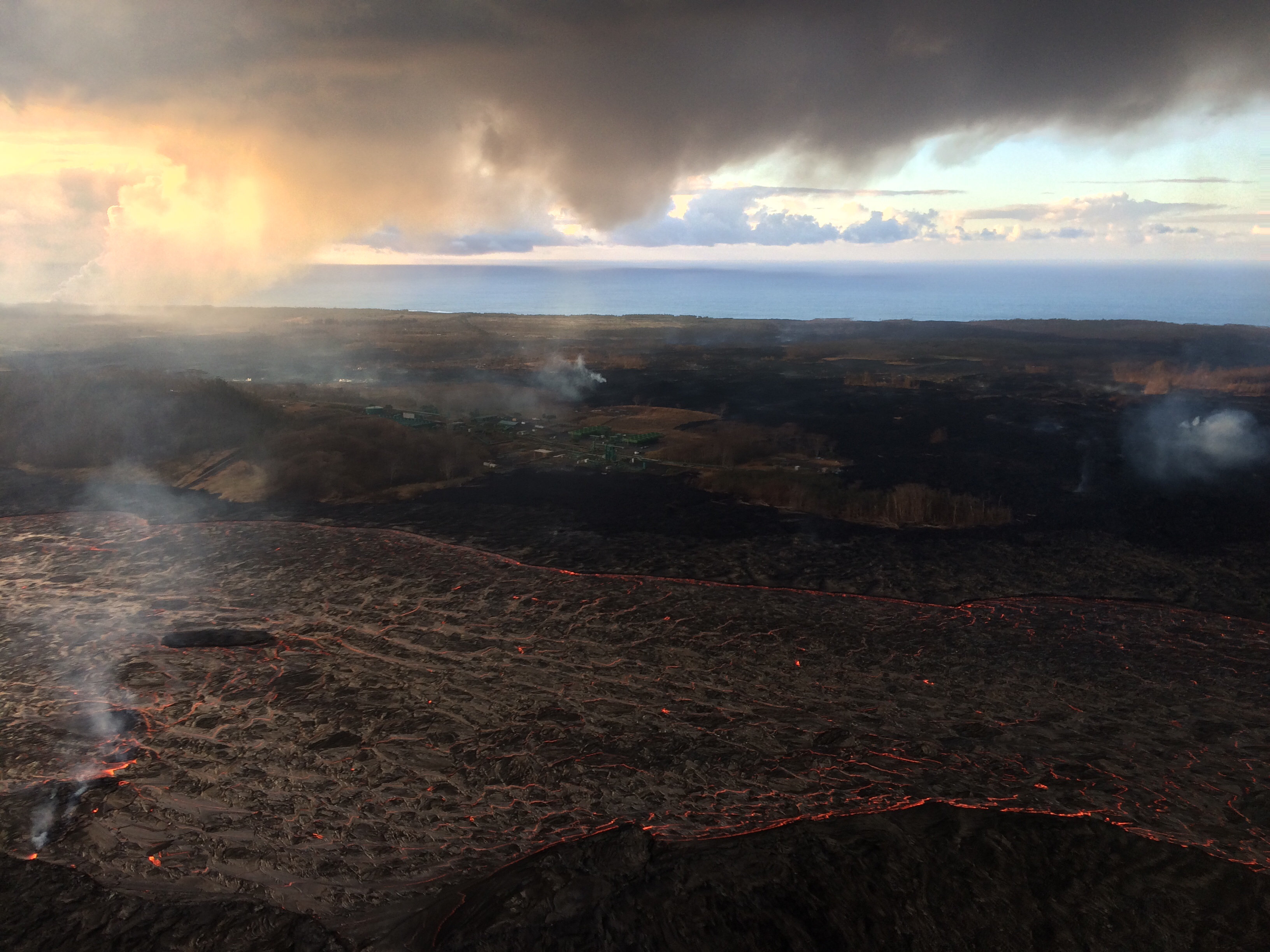
The LERZ eruption continues as it has for several weeks now, which is actually remarkable. Fissure 8 has added bulk (width) but not much height to its cone. Fissure 6 was active again last night with a sluggish little flow, while 16/18 and 22 showed early-morning incandescence.
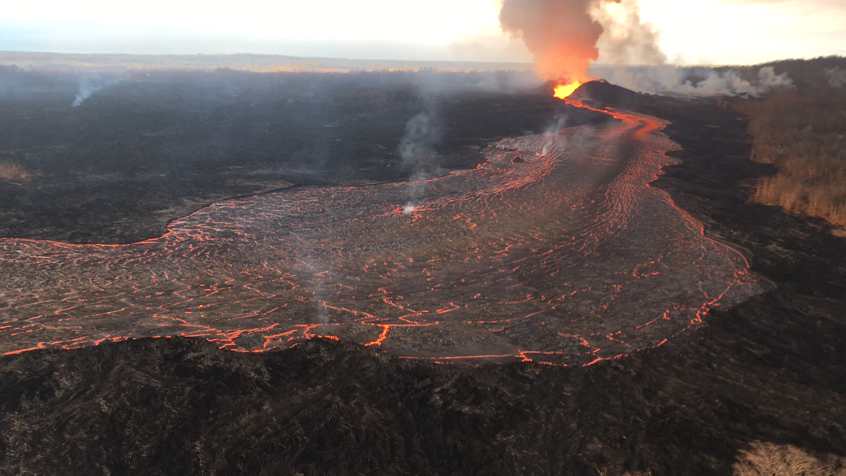
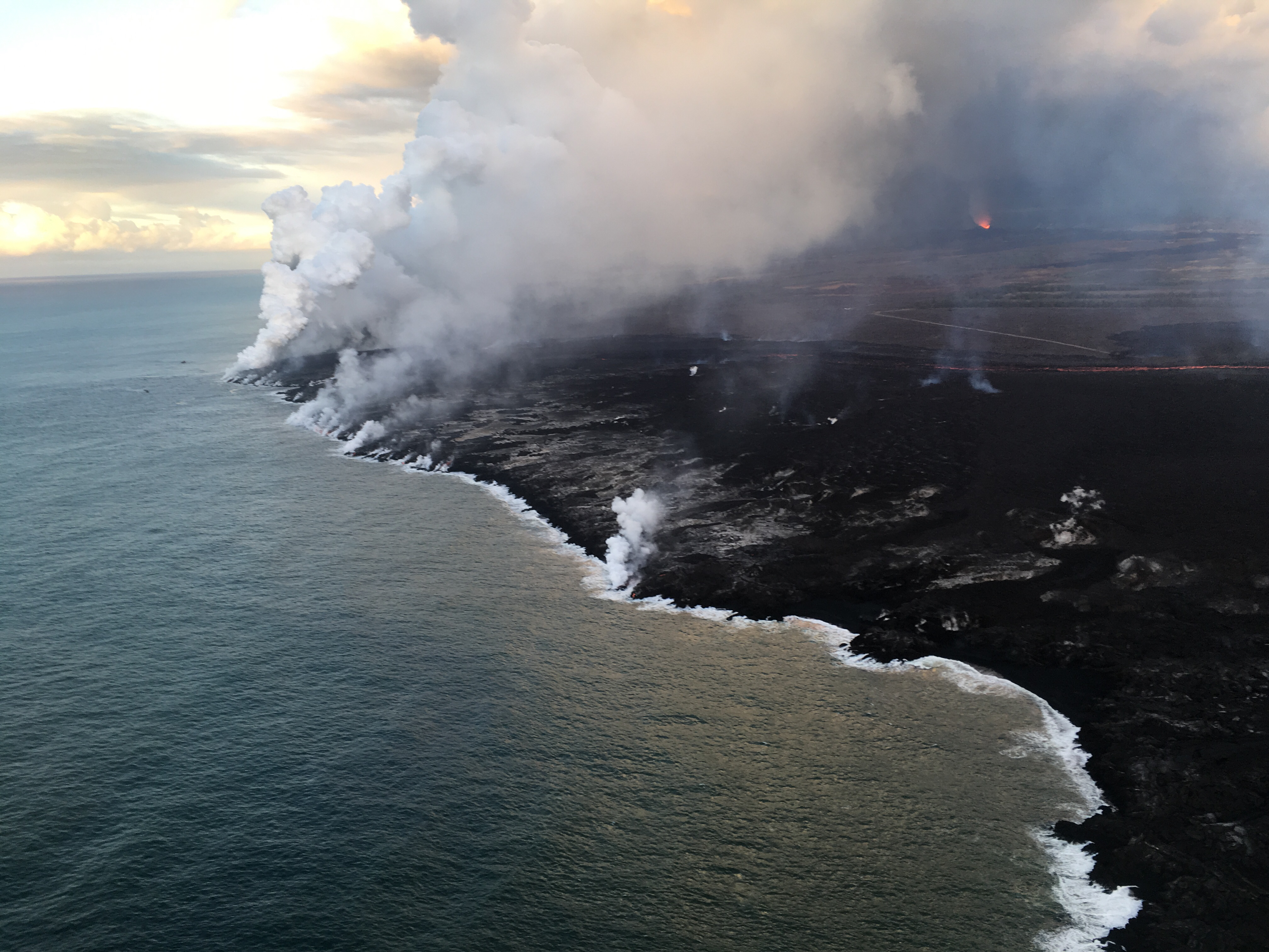
Fissure 8’s lava flow cruises along at 17mph in an elevated channel 50-60 feet high, slowing gradually to 2mph by the time it rounds the bend at Kapoho Crater. Its 8 mile journey concludes in the ocean and a burst of laze and fresh black sand, just a little further out each day. The lava delta has grown to 380 acres.
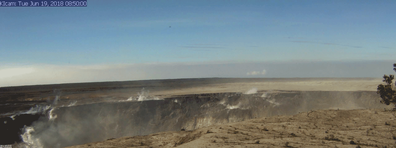
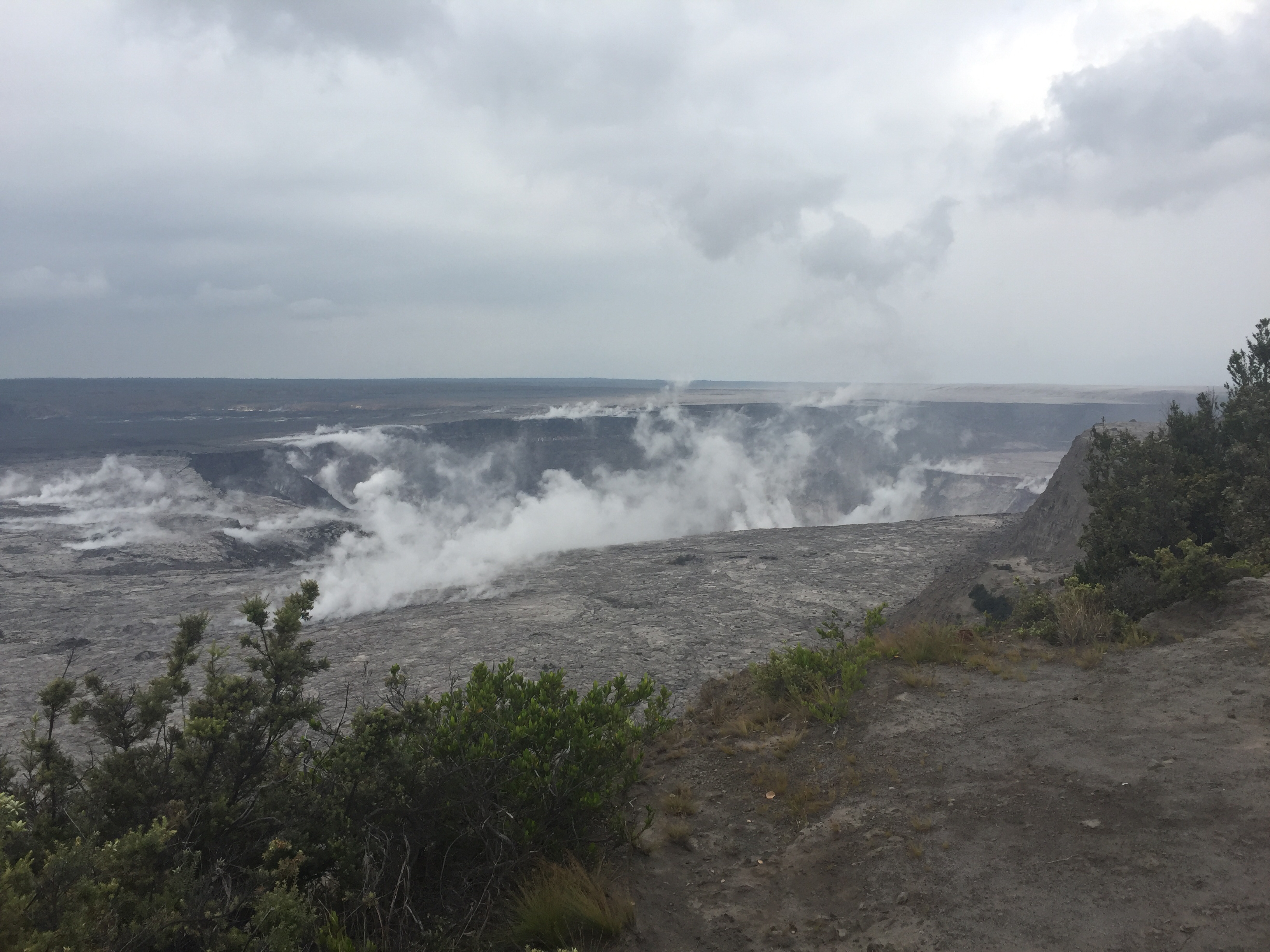
Halema’uma’u Crater at Kilauea’s summit continues to expand its gaping cavity by about 14 million cubic meters a day. The summit explosion for today occurred at 1:13pm HST, as usual registering as magnitude 5.3, with a minor ash & gas plume about 1000 feet high:
summit explosion caught on livestream
Captured from the USGS/HVO Kilauea Livestream. That enormously long crack on the right especially impressed me. Below, I’ve made a before-and-after animation to show some of the changes at Halema’uma’u over the last two days, using screengrabs from HVO’s webcam.
While Kilauea can’t sit still, Mauna Loa’s status has been downgraded to GREEN following six months of “near background level” seismic activity. See the “remarks” section of the USGS June 21 Mauna Loa update explaining the context for this announcement and Mauna Loa’s behavior over the past five years.
June 19 Montage of Leilani Estates at Night
Good video reminding us of where it all started, Leilani Estates, as well as the unforgettable sound of Fissure 8 roaring:
USGS 1.5 Minute Briefing
Liz Westby, USGS Geologist (Transcript)
USGS Photos, Social Media Q&As
Q: Will the White House’s new gag order on the USGS affect Kilauea updates? USGS: Our updates and information delivery are not being impacted. [CALL YOUR REPS ANYWAY; one-way “updates and information delivery” may not be impacted, but the ability of the press to interview USGS scientists or ask questions IS.]
Q: [Regarding Mauna Loa announcement] What does “near background seismicity” mean?
USGS: Active #volcanoes have a “fingerprint” – a way of behavior that’s unique to it specifically. USGS #VolcanoHazardsProgram (as its 5 volcano observatories) monitors volcanoes to determine fingerprint (background level of activity) and watch for deviations away from the norm.
Q: How far can lava flow before it loses too much heat to stay liquid?
USGS: An 1859 lava flow on Mauna Loa traveled more than 50 km (31 mi) before it hit the ocean, so at least that far.
Q: Will the lava delta remain, erode? Can it ever be built on?
USGS: The town of Kal[s]pana was consumed by lava, as was Kaimū bay (1990). Because the Kapoho Bay area was relatively shallow, we expect this land will remain intact and develop a black sand beach – much like Kaimū beach 300 yards from the old Kaimū bay shoreline.
Q: [Regarding today’s 5.3 summit explosion] Has it created any changes within Kilauea? How will it affect the LERZ lava flow, especially Fissure 8?
USGS: No change. This is the normal (pretty much daily now) M5+ event that signals a pressure release from the summit magma storage region.
Q: What is creating all the seismic events near Halema’uma’u?
USGS: In general, the withdrawal of magma from the storage region beneath the summit. Magma is moving into the East Rift Zone and decreasing pressure within the system that used to hold up the surface…so the surface is responding by fracturing and sinking. The fracturing records as earthquakes. [They dodged the more complicated question of the exact mechanism driving the explosive events and explained all the other summit quakes.]
Q: Will the magma chamber beneath the crater refill?
USGS: Kīlauea Volcano is in its very early life. The summit magma storage region will certainly refill. Presently, we are still seeing magma draining into the East Rift Zone, though not necessarily out of the LERZ eruption site. There is a lot of distance in the subsurface and a lot of space for magma to fill in.
Q: [Regarding summit explosion livestream]: Some of the ash plume seemed to originate from a different spot?
USGS: Just before the M5.4 there were precursory earthquakes that caused several rockfalls from the caldera walls (as well as Halema‘uma‘u). The rock dust from those blew in front of the camera right before/during the larger event.
Q: Why did it take 35 minutes for the 5.3 earthquake to be listed, after other, later earthquakes were listed?
USGS: These events are explosion events rather than earthquakes, so they are not automatically posted by USGS. [Instead they are manually reviewed.]
Finally, the USGS posted a really good essay on Facebook, rather than on any easily-accessible USGS website: “What’s in a name?” about naming Fissure 8 or renaming Halema’uma’u.
Highway 130 Traffic Cam
HDOT has reactivated traffic cams in the Puna district and added a thermal cam for Highway 130’s plate-covered cracks. Yikes:

From Local News Outlets
- HSA: “Volcanoes park museum artifacts, archives moved to safety“
- HTH: “Eruption shows no signs of slowing”
- HPR: “The Conversation: Volcano Recovery Efforts” (audio, including Will Okabe, Managing Director for County of Hawaii, and Jessica Ferracane, NPS)
- HNN: “As Kilauea volcano rages, Mauna Loa goes quiet”
- HNN: “After 7 weeks, eruptions on Big Island show no signs of stopping”
- HSA: “Officials hope to create safe lava viewing area”
- KITV: “Officials citing and arresting those snapping selfies near lava”
- HCB: “Slideshow: The Big Islands Latest Scenes of Destruction” (great photos)
- BIVN: “Puna Traffic Cams Resurrected, New Alternative Route Planned”
- HTH: “Mayor Kim out of hospital, back to work”
- HSA: “Lava’s ravages take a toll on residents’ mental health”
- HNN: “Volunteers warm lava evacuees’ hearts — by filling their stomachs“
- HSA: “Free medical care available this weekend for Big Isle Residents”
#LeilaniEstatesEruption #KilaueaVolcano UPDATE: The glow from #Fissure8 seen from #MaunaKea as Hawaiʻi’s Supreme Court hears arguments over a construction permit for the controversial #ThirtyMeterTelescope project on the Mauna summit https://t.co/D1HwQ9Q7RA @HawaiiNewsNow #HINews pic.twitter.com/Lq3jJKh9wW
— Mileka Lincoln (@MilekaLincoln) June 21, 2018
Moment of Aloha
- Dispatches from Volcano posted a lovely piece today, including memories and photos of the Queen’s Baths which I’m so sorry I didn’t see in 1986.
From Social Media
Yeah, I spoke with one of the geologists and it's too messed up. The faults that are underneath it have been active for weeks. It gets hit hard by every quake and then add in the slumping.
— lavapix.com (@lavapixcom) June 22, 2018
Aha! Lavajavadude on Hawaii Lava Update blog is @BruceOmori, photographer for Extreme Exposure Fine Art Gallery. His June 21 blog post includes fine photos plus observations of his last overflight with Mick Kalber. Here’s two more of his photos:
Wednesday, June 20, 2018, 5:45 am – Kilauea's east rift zone overflight: A view of fissure 8, as the light winds allowed the plume to rise straight up.
Posted by Extreme Exposure Fine Art Gallery on Wednesday, June 20, 2018
See rest of this photo gallery
Thursday, June 21, 2018, 5:45 am – Kilauea's east rift zone overflight: Howzit, bruddah Ikaika Marzo!!! Ikaika, doing…
Posted by Extreme Exposure Fine Art Gallery on Thursday, June 21, 2018
See rest of this photo gallery
And here’s the view from that boat!
Kapoho Ocean Entry this morning 6/21/18 aboard Kalapana Cultural-ToursKalapana Cultural Tours Lava Vessel the OHANA….
Posted by Ikaika Marzo on Thursday, June 21, 2018
Another view of the ocean entry by volcano master photographer GBradLewis:
Screengrab from summit webcam today:
Looking through the layers of time….
Mahalo #Kilauea …..
And you as well #Pele#KilaueaErupts #kilauea #LeilaniEstatesEruption #Pohoiki #kapoho #lowerpuna #puna #Pahoa #lavaflow #lavaflows pic.twitter.com/Hj4noYihOR— Tay Austin (@Jasamsdestiny) June 22, 2018
Incredible show of incredibly dangerous littoral explosions from the vigorous ocean entry of lava from #KilaueaEruption near #Kapoho earlier this evening. @USGSVolcanoes pic.twitter.com/1Q0eqGbgJL
— the Weatherboy (@theWeatherboy) June 22, 2018
How did we get to the ocean entry by Kapoho? On Ikiaka Marzo's Kalapana Cultural Tours Ohana of course! #KilaueaEruption pic.twitter.com/H5kX0Rygmp
— the Weatherboy (@theWeatherboy) June 22, 2018
What a difference a block makes inside #LeilaniEstates which is under siege from #KilaueaEruption. Cracks emitting plant-killing sulfur dioxide in one while green lawns and blooming anthuriums exist in another. Both inside mandatory evacuation area. pic.twitter.com/zuNS3CdcVY
— the Weatherboy (@theWeatherboy) June 22, 2018
Still no bus service in the evacuated/abandoned portion of #LeilaniEstates. Just 7 weeks ago, this was a bustling residential community. Now it sits frozen in time as sulfur dioxide suffocates the landscape, taking suburban living dreams with it here in #Hawaii. 😥 pic.twitter.com/tadtlH5Gok
— the Weatherboy (@theWeatherboy) June 22, 2018
Madame Pele is a drama queen of sorts: stunning, dramatic images stun the eyes and the souls where lava meets the sea. #KilaueaEruption pic.twitter.com/TEJ7NtXVQC
— the Weatherboy (@theWeatherboy) June 22, 2018
What once was:
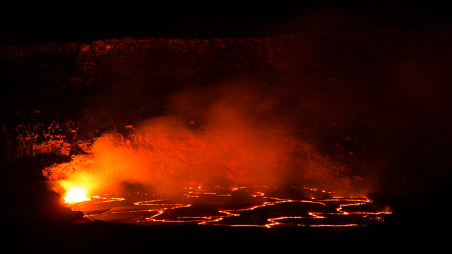
Creative Commons photo of Kilauea lava lake, May 6, 2015 by Frank Wittig