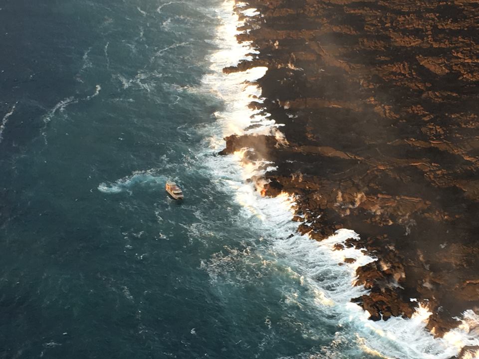
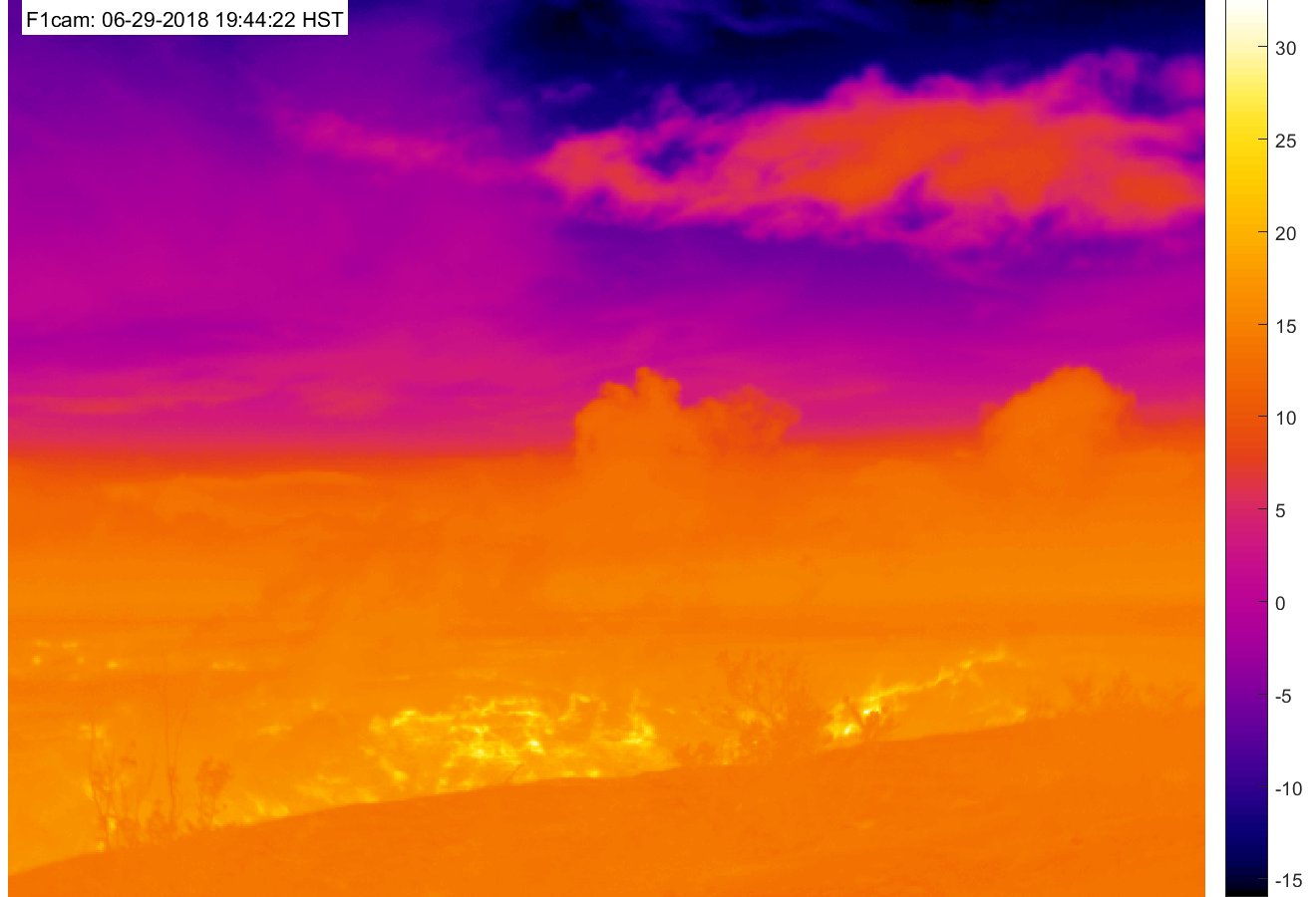
September 2: A Few Signs of Life Deep in Fissure 8


Saturday, Sep 1, 2018, 6:00 pm – Kilauea's lower east rift zone overflight: Another angle of fissure 8, with a small lava pond within.

Posted by Extreme Exposure Fine Art Gallery on Sunday, September 2, 2018

This Week’s Eruption Summary

While no glow or incandescence was reported within Fissure 8’s cone for most of the week, Saturday 9/1 showed a few life signs remain in the LERZ: weak spattering from one spot, and in the evening new lava came out to cover most of the crater floor. But its sides have been slumping and falling in, as have the levees of the now solidified lava channel. While Fissure 8 and some of the surrounding vents continue to steam and fume, SO2 emissions remain low there and at the summit.

August 30, 2018. USGS: “The fissure 8 lava channel (center) and levee (foreground), looking toward the northwest. Loose rubble and Pele’s hair (lower right) are strewn across the levee surface.” (Full-sized)

No active ocean entries have been seen for the past few days, suggesting that all the residual lava from Fissure 8 has stagnated or drained out.

August 30, 2018. USGS: “Lower East Rift Zone lava flows entering the ocean have built a lava delta over 875 acres in size, but no active ocean entries were observed by HVO geologists on this morning’s overflight. View to the southwest.” (Full-sized)

This week has been a time of repair and taking stock. USGS geologists have been replacing lost or damaged monitoring stations (including the UWE tiltmeter, back on HVO’s deformation page). The drone crews have been out after Hurricane Lane came through to take new detailed aerial surveys of Kilauea’s summit (August 30 video) and Fissure 8 (August 21 video).
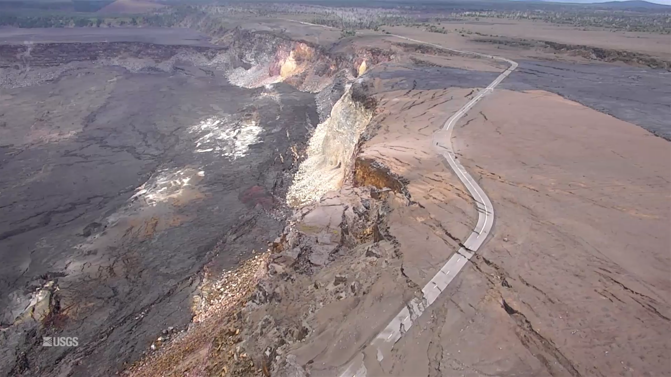
Screencap from August 30, 2018 UAV video survey of Kilauea summit.

They also posted an updated timelapse video of HVO’s panorama cam of Halema’uma’u from April 14 through August 20:

This week’s Volcano Watch newsletter from HVO describes how “Scientific community lends a hand to measure Kīlauea’s changing shape.” This eruption required all hands on deck and every last scrap of equipment they had, and then some.

Another screencap from the August 30 drone survey of Halema’uma’u Crater and its surroundings. Piece of Crater Rim Drive a long way down in the crater.More photos after the cut, plus some notes on the park’s status.


Continue reading September 2: A Few Signs of Life Deep in Fissure 8
August 27: After Fire, Flood (Hurricane Lane)

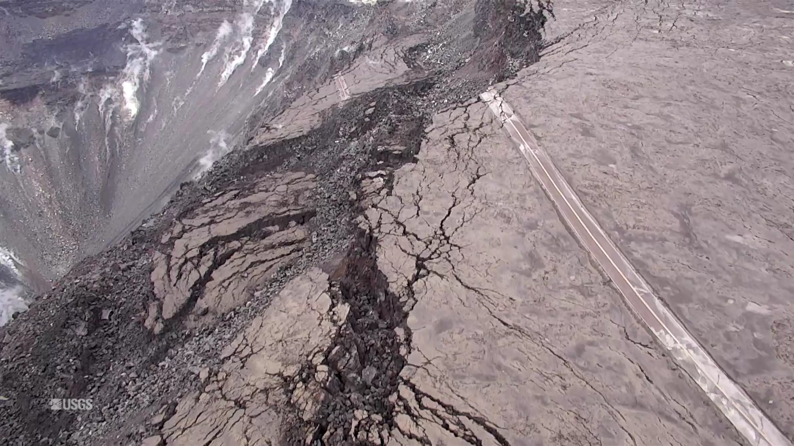
August 22, 2018. USGS: “Parts of Kīlauea’s caldera floor are now a jumble of down-dropped blocks and surface cracks. HVO field crews carefully hiked along Crater Rim Drive yesterday to verify the locations of USGS benchmarks (lower left), which will be used for additional geophysical work that will help document the recent summit changes. The view is to the northwest with one flank of Mauna Loa visible in the distance (upper right).” (Full-sized)
Weekly Eruption Summary

After a busy few months, Kilauea continues to rest with only a pilot light on, so to speak. This week’s big news was that Hurricane Lane passed offshore of the Big Island on Thursday through Saturday, causing extensive flash flooding. But there’s still a little news to report on the dying (?) embers of Kilauea’s 2018 eruption.

On Friday morning, the Hawaii County Fire Department observed a small lava pond still visible deep in Fissure 8’s cone. For most of the week, there was no visible activity apart from a few small jets deep in the cone throwing weak spatter on Monday morning:

August 20, 2018. USGS: “This morning, USGS scientists flying over fissure 8 noticed a change in the vent from yesterday. Gas jets were throwing spatter—fragments of glassy lava (light gray deposits)—from small incandescent areas deep within the cone. This activity is an indication that the lower East Rift Zone eruption may be paused rather than pau (over).” (Full-sized)

The sputtery jets proved to be temporary:

August 21, 2018. USGS: “Southward facing aerial view of the fissure 8 cone. The two small areas of incandescence, gas jetting, and spatter from yesterday photograph appeared crusted over today.” (Full-sized)

Down at the ocean at Kapoho, there were a few weak dribbles of lava continuing to drain out of the delta at the beginning of the week:

August 20, 2018. USGS photo of residual lava entering ocean, posted on their facebook page here.

Sulfur dioxide emissions continue to be very low both at the summit and the coast. In fact, on Tuesday, they dropped too low in the Lower East Rift Zone for instruments to measure, although not too low for highly-sensitive human noses to detect.

Video from August 17 posted on the 20th— full-sized version here.

Heavy rain from Hurricane Lane on Friday and Saturday put a hold on USGS overflights and field observations and knocked out a few sensors on the east side of the island. But Kilauea’s extensive sensor network means there was no gap in volcano monitoring, and field crews were on call just in case.

The hurricane had no impact on the volcano apart from heavy rainfall hitting hot rocks and turning to steam in Pu’u O’o’s crater and on the not-yet-cooled lava flows of the LERZ. There were some reports of local white-out conditions from this steam. Rain may also have triggered a few rockfalls at the summit.

The other big Kilauea news this week is that Hawaii Volcanoes National Park has set a target reopening date for September 22, aiming to reopen at least the Visitor Center and (they hope) some kind of viewing area from which visitors will be able to see the new, larger Halema’uma’u Crater. They’re also hoping to open Volcano House, but they need to check the stability of the cliffs on which it stands.

USGS Volcano Watch

Whoops! I think I missed last week’s edition. This is Hawaiian Volcano Observatory’s weekly column with photos and in-depth information on some aspect of Kilauea.

Continue reading August 27: After Fire, Flood (Hurricane Lane)

July 28: Kīlauea LIDAR Data – 3D Renders by Fumihiko Ikegami

Remember how OpenTopography.org recently posted LIDAR surveys of Kilauea from 2009, June and July 2018?

Well, volcanology PhD student Fumihiko Ikegami (@fikgm on Twitter) has been creating great 3D renders using this data.  Click on images below for large-size views of each render.

You can turn, zoom, and view this 3D model from any angle:

Before it all started— years ago, Ikegami created these using the 2009 data:

Continue reading July 28: Kīlauea LIDAR Data – 3D Renders by Fumihiko Ikegami

July 16: Lava Boat Tourists Injured

July 16, 2018. USGS: “The active ocean entry along the southernmost margin of the fissure 8 flow is a hazardous area. The interaction of lava and seawater creates “laze,” a corrosive steam plume laced with hydrochloric acid and fine volcanic glass particles that is blown downwind and can irritate the skin, eyes, and lungs. Lava flows entering the ocean can also result in explosive interactions, littoral explosions, that can hurl fragments of molten lava and rocky debris hundreds of meters (yards) inland and seaward.” (Full-sized)
Today’s Eruption Summary

The big news today was a lava tour boat getting pelted by lava chunks from an ocean entry explosion, resulting in burns, bruises, and one broken leg. Next to that, the science of this eruption seems a bit trivial. But this blog is primarily oriented towards the latter, so let’s get volcanology news out of the way first.

The Italian Space Agency released a new CosmoSkyMed radar scan of Kīlauea’s summit. Let’s hope this really is the new northern extent of Halemaʻumaʻu:

May 5-July 16, 2018. USGS: “Over time, expansion of the summit eruptive vent within Halema‘uma‘u crater and the widening of Halema‘uma‘u itself are obvious. Starting in late May, the development of several cracks outside Halema‘uma‘u is clear, and inward slumping of a large portion of the western, southwestern, and northern crater rim begins. Much of this motion appears to be coincident with the small explosions from the summit that have taken place on a near daily basis since early June. The most recent radar scene, from July 16, shows continued motion along cracks over a broader area of the caldera floor, extending east of Halema‘uma‘u. We expect this slumping to continue as long as the collapse events and overall subsidence persist.” (Full-sized)

This morning, over 24 hours after the previous summit collapse, the lava channel below Fissure 8 was full but not overflowing. Even after today’s 11:42am summit collapse, there was no observed surge— “Nothing notable in the way of overflows.” Last night’s field crews heard Fissure 22 grumbling to itself, but saw no visible signs of renewed activity.

According to Civil Defense this afternoon, the southern edge of the main lava flow has stalled 1 km from Isaac Hale Park / Pohoiki boat ramp. Just north of there, the new ocean entry at Ahalanui is vigorous and dangerous. That’s where @hotseathawaii filmed an offshore explosion four days ago. There were more explosions this morning, “with at least one being quite strong” (USGS).

(The summit collapse was M 5.3 again. The livestream is still ailing, but even so it captured rockfalls, camera shake, and the earthquake’s progression from far to near in the field of view.)

July 16 Map of Active Lava Flows

Lava delta is up to 690 acres, by the way. “Tiny no-longer-island” is next to the c in “former coastline.”

USGS map of LERZ lava flows as of July 15, 2018, 1 pm HST. Yes, the tiny no-longer-an-island is visible in the full-sized image.

Continue reading July 16: Lava Boat Tourists Injured

July 3 Steve Brantley Slideshow at Pahoa Meeting

[Note: this is when the overflows around Kapoho Crater got started, but the main flow front/ocean entry was still mostly north.]

I was hoping NLTV would post a video of last Tuesday evening’s Pahoa Community meeting as they usually do, since BigIslandVideoNews records Steve Brantley’s slideshows by pointing the camera at him and skipping most of the slides, but no such luck.

BIVN posted various excerpts of the meeting, including these non-geology segments: Live poll, Hwy 130 Reopening Discussed, Residents question Civil Defense. 

Here’s Steve Brantley’s USGS presentation:

Transcript

Steve Brantley, Deputy Scientist-in-Charge of HVO:

Continue reading July 3 Steve Brantley Slideshow at Pahoa Meeting

July 8: Ahalanui Warm Pond, School Under Lava Threat

Today’s Eruption Summary

The LERZ continues as usual, although there are tantalizing hints that change could be on the way:

July 8, 2018. USGS: “Fissure 8 (lower right) and open lava channel leading to the northeast. Geologists noted small lava-level fluctuations in the open channel overnight, which indicates intermittent variations in lava discharge from fissure 8. An increase in lava levels was noted about 1.5 hours after the collapse-explosion event at the volcano’s summit at 02:55 a.m. HST. Evidence of a couple of recent, short-lived channel overflows were observed early this morning, but they had not reached the edge of the flow field. The small steam plumes in distance mark locations of fissures that erupted in early May at the beginning of the ongoing eruption.” (Full-sized)

Fissure 8 gushes within its large cone, Fissure 22 continues to spatter weakly. The open lava channel from Fissure 8 now ends about 2km (1.2 mi) from the coast:

July 8, 2018. USGS: ” View of the partially filled Kapoho Crater (center) and the open lava channel where it makes a 90-degree turn around the crater. The open channel no longer directly enters the ocean. Lava flows freely through the channel only to the southern edge of Kapoho Crater (left side of image). Clearly, lava moves into and through the molten core of the thick ‘a‘ā flow across a broad area from both the sides and end of the channel.” (Full-sized)

From the end of the channel, the lava dives under the crust of the slightly older flows that buried Kapoho Bay. It emerges again along a very broad ocean entry:

July 18,2018. USGS: “Multiple ocean entries were active this early morning, each contributing to the prominent “laze” plume above the area. Lava moves from the open channel through the molten core of the broad ‘a‘ā flow field to the ocean. Kapoho Crater is at middle right of photo.” (Full-sized)

According to USGS/HVO, the ocean entry is “primarily along the northern section,” as it has been for the past few weeks. However, to judge by today’s @hotseasthawaii overflight, there’s notable ocean entries to the south as well. Besides the lava that reaches the ocean, USGS reported lava “oozing out” to the north and southwest of the main a’a field just inland, as one can see on Friday’s thermal map. A few Kapoho Beach Lots houses are hanging on, threatened by the northern “ooze-out.” The southwestern “ooze-out” — several local photographers have reported an unconfirmed  “southern lobe” lava flow— is within a few hundred yards of Ahalanai Warm Pond and Kua O Ka La Charter School:

Screencap from early morning July 8 HotseatHawaii overflight. Ahalanui Warm Pond is just at the end of that straight stretch of Hwy 137, and the school is the light-colored patch just to the right of it. (Full-sized)

The most recent summit collapse event occurred at 2:55am HST, July 8, with an energy release of M5.4.

Italy’s Cosmo-Skymed satellite sent down another radar image of Kilauea caldera today:

July 8, 2018. USGS: “This animated GIF shows a sequence of radar amplitude images that were acquired by the Agenzia Spaziale Italiana CosmoSkyMed satellite system. The images illustrate changes to the caldera area of Kīlauea Volcano that occurred between May 5 and July 8 at about 6:00 a.m. HST. […] The most recent radar scene, from July 8, shows continued motion along cracks over a broader area of the caldera floor, extending east of Halema’uma’u (these cracks are the scarps seen in recent photographs from the Keanakākoʻi overlook area).” (Full-sized)
Continue reading July 8: Ahalanui Warm Pond, School Under Lava Threat

June 30: Kapoho Beach Lots Burning Again

Fissure 8 continues to behave much as it has for the last month or so, looking ever more like a Mordor backdrop:

June 30, 2018: Fissure 8 looking Mordor-like during the USGS morning overflight. (Full-sized)

Today’s official HVO Kilauea update is a copy-and-paste of yesterday’s, apart from this small addition describing the lava delta: “lava is moving beneath the crust and into [the] still-molten interior of earlier flows before it enters the sea in multiple oozeouts.” Like this:

USGS: “Lava was entering the ocean over a broad area this morning. This image shows an active entry area along the northern flow front at Kapoho. View to the south.” (Full-sized)

Unfortunately, some of those “oozeouts” are occurring at the edge of Kapoho Beach Lots as well. At least one home burned today, perhaps more.

Check the Hawaii County Fire Department photos later in this post (or the Bruce Omori photos at the end of the post) to see what the slow-moving expansion into Kapoho Beach Lots looks like right now.

USGS: “View of Kīlauea Volcano’s summit [from Volcano House, I think]. The brown visible dust coming from Halema‘uma‘u is from rockfalls.” (Full-sized)

Kilauea’s summit is changing visibly day by day. Today’s collapse explosion came at 2:51pm, 31 hours after the previous event. Mag 5.3, as usual, with a 500-foot ash-poor plume (captured on livestream). It was somewhat obscured by dust from multiple rockfalls 3 minutes earlier. Here’s a before-and-after:

More USGS Morning Overflight Photos

Continue reading June 30: Kapoho Beach Lots Burning Again

June 29: New Ways to Watch Changes at the Summit

Today’s Eruption Summary

Fissure 8 and the summit explosions continue their status quo. However, for the last few days, the lava flow at Kapoho has been encroaching on new areas on its northern and southern boundaries at the coast.

At least 3 more Kapoho Beach Lot houses have burned on the north side, and the southern edge of the flow is burning vegetation and/or farmland west of Highway 137. I gather these new lateral outbreaks are due to the lava channel crusting over, about half a mile inland from the new coastline (see Wednesday’s thermal map). So instead of pouring straight from the channel into the ocean, lava is fanning out under the crust of the 2-mile-wide lava delta laid down earlier this month, then oozing out the sides.

[USGS drone footage of Fissure 8 from before dawn. They’re using drones for the first time to map flows, look for outbreaks and measure the lava river’s speed.]

At Kilauea’s summit, today’s collapse explosion occurred at 7:51am HST, June 29, with an ash-poor steam plume that rose 500 feet. (Steam?)The energy release dropped slightly to 5.2. I didn’t do a video capture, since the summit was blanketed in morning fog.

The “new news” today is that HVO has added two new views to its Kilauea Webcams page. One I’ve mentioned before, the old “Kilauea East” webcam from HVO’s 1990s website which has annoying reflections but a great view of the subsidence/collapse on the east side of Halema’uma’u Crater:

June 25, 2018 screengrab from “Kilauea East” webcam.

The other is a new heat-sensitive webcam which should make it possible to see “collapse explosions” at night:

Screengrab of Halema’uma’u Thermal webcam at sunset, June 29.

Also, in this week’s “Volcano Watch” newsletter, Hawaiian Volcano Observatory scientists explain the “piston” model they’ve developed to account for the daily collapse explosions at the summit:

(See also the “Kilauea Earthquakes FAQ” they posted earlier this week.)

This is big news. They’ve solved the mystery of the summit explosions! Subject to revision, of course; they’re still untangling the complexities of Kilauea’s current eruption. But the “piston” model accounts for the cyclical pattern they’re seeing better than the “steam explosion” model.

Continue reading June 29: New Ways to Watch Changes at the Summit

June 21: USGS Media Conference Call

Here’s my transcription of the June 21, 11AM USGS media conference call.

  • Host: Leslie Gordon, USGS Public Affairs
  • Mike Zoeller, UHI Geologist
  • Matthew Foster, NWS meteorologist
USGS: “The USGS UAS (unoccupied aircraft system) team took this photograph of Halema‘uma‘u Crater from the Kīlauea Overlook on this morning. They are preparing for a flight to map further subsidence at the summit.” (Full-sized)
Summary:

Update: Status quo at Fissure 8, LERZ, Summit. New “tidbit”: front of lava is sitting on ocean floor that was 60 meters deep. Also, using term “collapse explosion” for daily explosions, because not 100% clear whether explosion triggers collapse or vice versa. Tradewinds and showers through weekend.

Questions & answers: 

  1. Q: Possibility of new fissures opening, or if not, why not? Has seismicity in LERZ decreased? A: Not ruling it out, but magma has found a good conduit to Fissure 8, seems stable. Seismicity in LERZ “pretty quiet.”
  2. Q: Trump administration tightening rules on USGS speaking to reporters; will that impact our communications? 

Leslie Gordon, USGS Public Affairs: That will not affect what we’re doing here at Kilauea. I think the department realizes that this is an urgent situation. We have people’s livelihoods endangered. People have lost their homes and businesses. And so we— it will not affect what we’re doing here regarding Kilauea Volcano.

3. Q: Do you think it’s safe local residents to view lava if they’re outside mandatory evacuation zone?  A: Not our call. It’s up to Hawaii County.
4. Q: What’s process for naming fissure 8? A: Hawaiian elders, community, Board on Geographic Names decide when and what to call places in Hawaii.
5. Q: Will delta collapse? How far out? A: Can’t rule out collapse, but it’s on fairly stable slope so far; 100-200 meters from where it is now the slope steepens. [Didn’t say what would happen there, but I think implication is that it will be less stable and more collapse-prone.]

Continue reading June 21: USGS Media Conference Call

June 18: USGS Kilauea Conference Call

BigIslandVideoNews posted an abridged version of today’s USGS Media Conference Call:

Here’s the full unabridged audio recording.  Below, I take notes/paraphrase, for anyone who’s especially interested in the nitty gritty of what’s going on with the volcano.

June 18 USGS 11AM Media Conference Call

Continue reading June 18: USGS Kilauea Conference Call