July 5: Volcano Community Meeting

Informing the public without panicking them about an extremely unlikely but life-threatening hazard is tricky. So it’s taken the USGS a while to release this document which they’ve been promising the residents of Volcano:

On HVO website: Volcanic Hazard at the Summit of Kīlauea Update [summary: “This document is a guide for understanding current activity and hazard at and around the summit of Kīlauea Volcano. Here, we summarize activity from late April through the present, detail possible future outcomes, and review hazards associated with these outcomes.”]  Presumably it’s called an “update” because it supplements the June 26 “Frequently Asked Questions About Kīlauea Volcano’s Summit Earthquakes” FAQ. [EDIT: No, actually, it’s an update to the May 8th “Preliminary Analysis of Current Explosion Hazards at the Summit“]

This was the chief topic of Thursday’s Volcano Village meeting, led not by the National Park Service this time, but by Civil Defense Administrator Tal Magno.

Here’s the FULL video of the meeting. BigIslandVideoNews excerpted the most important part, HVO Scientist-in-Charge Tina Neal’s 4-minute talk:
Partial Transcript

Continue reading July 5: Volcano Community Meeting

June 28: USGS on Latest Changes to Kīlauea Caldera [Pt. 3 of 3]

This post got long, so I’ve moved the Q&A session to Part 3. Again, I’m transcribing what HVO geologists had to say at the June 28 Volcano Village community meeting.

Part 1 was Kyle Anderson’s talk on seismicity and ground deformation— lots of nitty gritty science— while Part 2 was Don Swanson’s slideshow of some of the visible changes he’s observed within Kīlauea Caldera, with a lot of photos I haven’t seen anywhere else.

Here’s the video of the whole meeting.

Here’s my transcription of the Q&A session. A lot of these questions have already been answered online, but I like hearing direct, personal responses from some of the senior HVO scientists:

Continue reading June 28: USGS on Latest Changes to Kīlauea Caldera [Pt. 3 of 3]

June 28: USGS Talk on Latest Changes to Kīlauea Caldera [Pt. 2 of 3]

This continues my transcription of the Thurs Jun 28 USGS presentation at Volcano Village. Part 1 transcribed HVO Scientist-in-Charge Tina Neal and seismologist Kyle Anderson’s remarks. Part 2 covers senior volcanologist and my longtime hero Don Swanson’s remarks.

Here’s the video of the entire 1.5 hour meeting. Don’s presentation starts at 15:50:

It sounds like Swanson’s been holed up in Volcano House after HVO was evacuated. (Kyle Anderson: “Don has spent more time viewing this eruption from the summit than anyone else.”)

Title of talk: “Comparisons of Halemaʻumaʻu Crater, May 19 through June 28
Viewed from dining room table of Volcano House”

Don Swanson, geologist, USGS

[15:50] Thanks, Kyle.

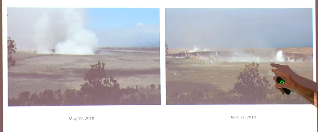
The data that Kyle showed are absolutely magnificent. What I want to do now is to show you some photographs of features that I’ve been able to see during my observations. The first will be a series of photographs of Halemaʻumaʻu taken from the seat in the dining room of the Volcano House hotel where I sit and observe things.

Screencap of first slide in Don Swanson’s presentation. In USGS archives: [May 19] [June 13]
On May 19th, of course, things were just starting to get going, but over here on June 13th, you can see that the crater has widened dramatically, and notice that it’s also dropped to the top of the tree which was way below the— it’s come way down. It isn’t because the tree is growing! It’s because the crater is dropping down.

Now we’ll go to this next period, June 13th to the 17th.

Continue reading June 28: USGS Talk on Latest Changes to Kīlauea Caldera [Pt. 2 of 3]

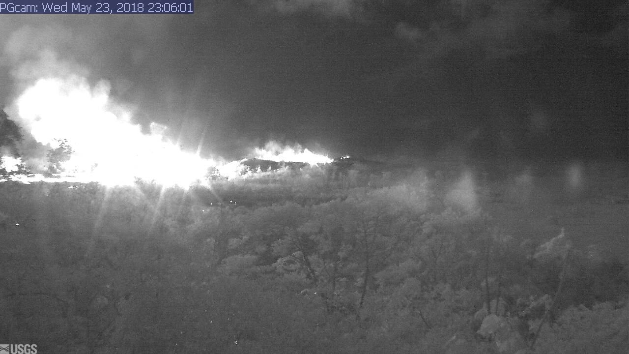
May 23: Blue Flames? Now You’re Just Showing Off

Kilauea’s chief resident has found another way to amaze and/or injure people reckless enough to get too close to her redecorating:

I had a hunch the Lower East Rift Zone webcam would be interesting tonight. I wasn’t disappointed:

I see what they mean about the Leilani fissures further west (uprift, towards the camera) reactivating today.

Edited to add: Yikes.

It’s 11:06 PM in Hawaii; second screengrab an hour or so later.

I was about to hit post, when I saw erstwhile reporter Mileka Lincoln and her crew posted this. Wow.

(recorded just an hour ago at time of this post.)

Now, let’s have the evening roundup of poignant news, amazing views, and interesting science…

Continue reading May 23: Blue Flames? Now You’re Just Showing Off

May 19 USGS Press Conference on Kilauea’s Explosive Side

BigIslandVideoNews just put up an edited video of Saturday’s USGS press conference. My hero Don Swanson is there. It’s INCREDIBLY informative on what they think is happening at the summit and why they think it’s a repeat of the “much smaller eruptions” of 1924 and not larger ones.

Transcription:

Continue reading May 19 USGS Press Conference on Kilauea’s Explosive Side

May 19 – Another Ash Explosion Last Night

USGS reports another explosion last night: “At 11:58 PM Local time, a short-lived explosion at from Halema’uma’u created an ash cloud that reached up to 10,000 ft asl and was carried southwest by the wind. Possible trace ash fall may have occurred along Highway 11.”

I’m not sure whether this was a steam explosion, or just yet another of these rockfall-triggered ashclouds, like this one in 2011:

Hawaii Volcano Observatory is so lucky to have one of the foremost experts in explosive eruptions, Don Swanon, who worked on St Helens so long ago and uncovered Kilauea’s explosive history after transferring to HVO in the 90s.

From KITV May 19:

Experts on this active volcano gathered to share what they know- and what they have discovered is Kilauea has a history of explosive ash eruptions. Hawaiian Volcano Observatory geologist Don Swanson sums, “For the past 2,500 years we’ve had explosions more than 50% of the time, so this is the norm for Kilauea. But most of the explosions are minor, like we saw today, with small plumes of ash and steam rising from the summit.”

About the 1790 Kilauea Eruption

Here’s a summary and primary sources collected by HVO geologist Don Swanson on a 1790 explosive episode of Kilauea.

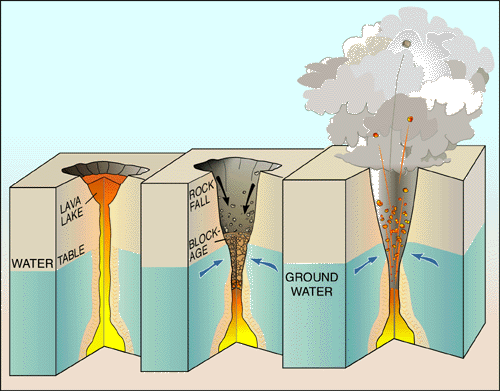
Also see USGS factsheet, “Explosive Eruptions at Kilauea, Hawai’i?” compiled prior to the 2018 eruptions. Diagram from this page:

3-part diagram: at left, a full lava lake with a long chimney of magma supplying it from below; in the middle is the same lava lake with the lava level dropping way down the chimney, below the water table, so that the upper walls of the chimney are cool enough for groundwater to seep in. Rocks falling from the chimney's walls are starting to choke it. The third and last phase of the diagram shows that groundwater has heated to steam and built up pressure below the rockfall until it builds up enough steam to shoot the blockage straight up out of the chimney.
USGS Diagram Explaining Cause of Steam Eruptions

The factsheet notes that “Many of Kilauea’s pre-1924 explosive eruptions that produced significant ash deposits probably happened when the volcano’s summit crater was so deep that its floor was below the water table, letting ground water seep in to form a lake.

If I’m understanding correctly, they’re saying that bigger explosions may happen when there’s a lake of water, i.e. more fuel to create steam.

Edited to add: HVO’s page outlining the history of Kilauea Caldera also goes into past explosive episodes. Final paragraph:

“Having pieced together the recent geologic past of Kīlauea, scientists conclude that the volcano will eventually return to a long period of mostly explosive activity, just as it did around 1500 CE. This future explosive period will probably accompany a significant decrease in the magma supply rate and be initiated by collapse of a new caldera to the depth of the water table, which today is about 615 m (2015 ft) below the present high point on the caldera rim. For now, effusive eruptions dominate Kīlauea.”

Note: that’s a new caldera, the much larger basin containing Halema’uma’u crater within it, and the vent that’s erupting ash explosions right now was a small lava lake covering only part of the floor of Halema’uma’u. Orders of magnitude different in terms of size. Also, changing the location of the active vent doesn’t mean the magma supply inside is dropping.