July 12: USGS Conference Call

There was a lot of good info in the Thursday conference call with members of the media. BigIslandVideoNews posted a recording of most of it:

Full audio archived here.

  • Leslie Gordon, USGS Public Affairs Officer
  • Matthew Foster, meteorologist, NWS
  • Jessica Ferracane, NPS, HVNP Public Affairs
  • Janet Babb, geologist, HVO/USGS
  • Mike Zoellner, geologist, Center for the Study of Active Volcanoes, UHI
Transcript – July 11 Eruption Update

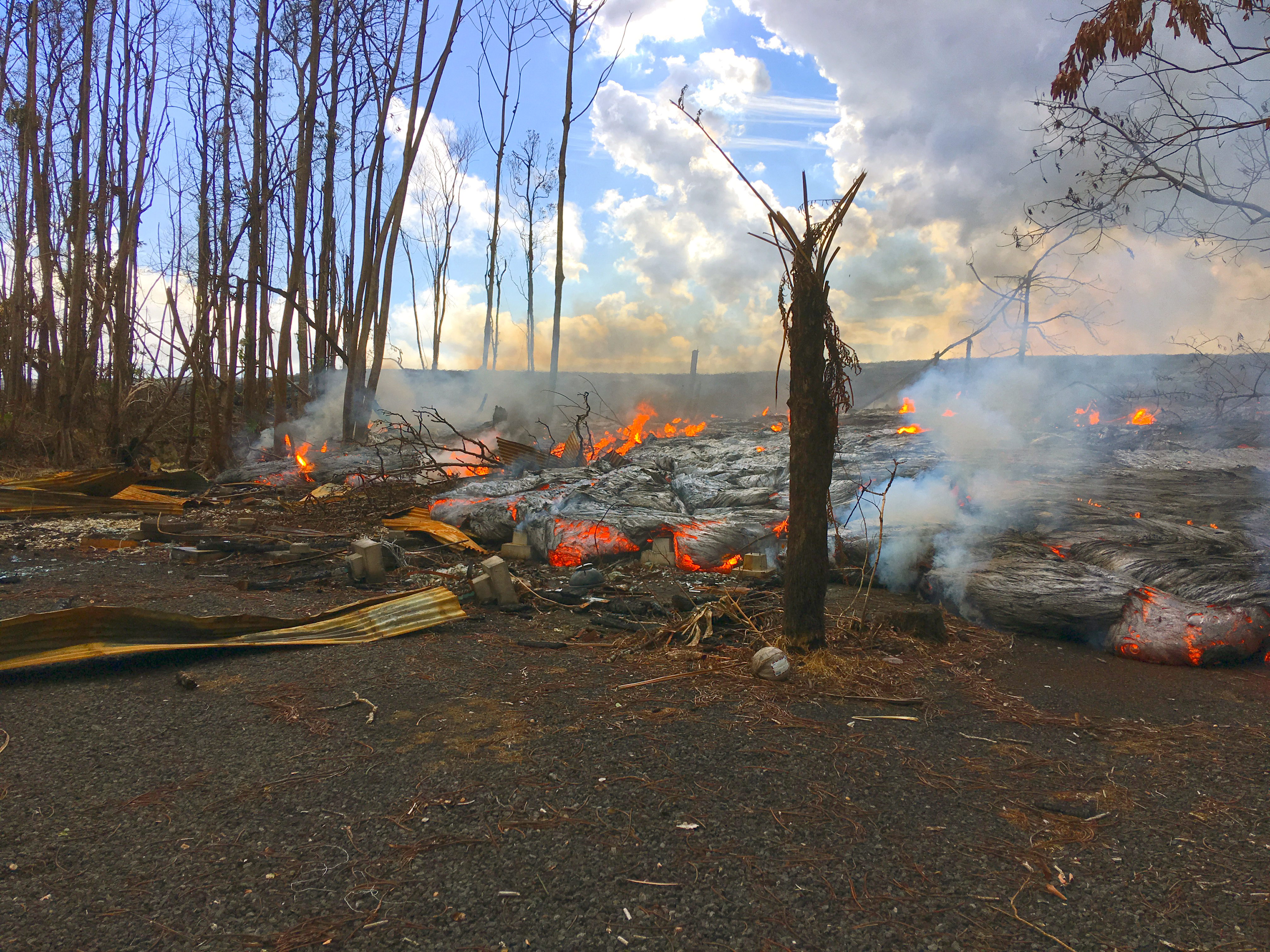
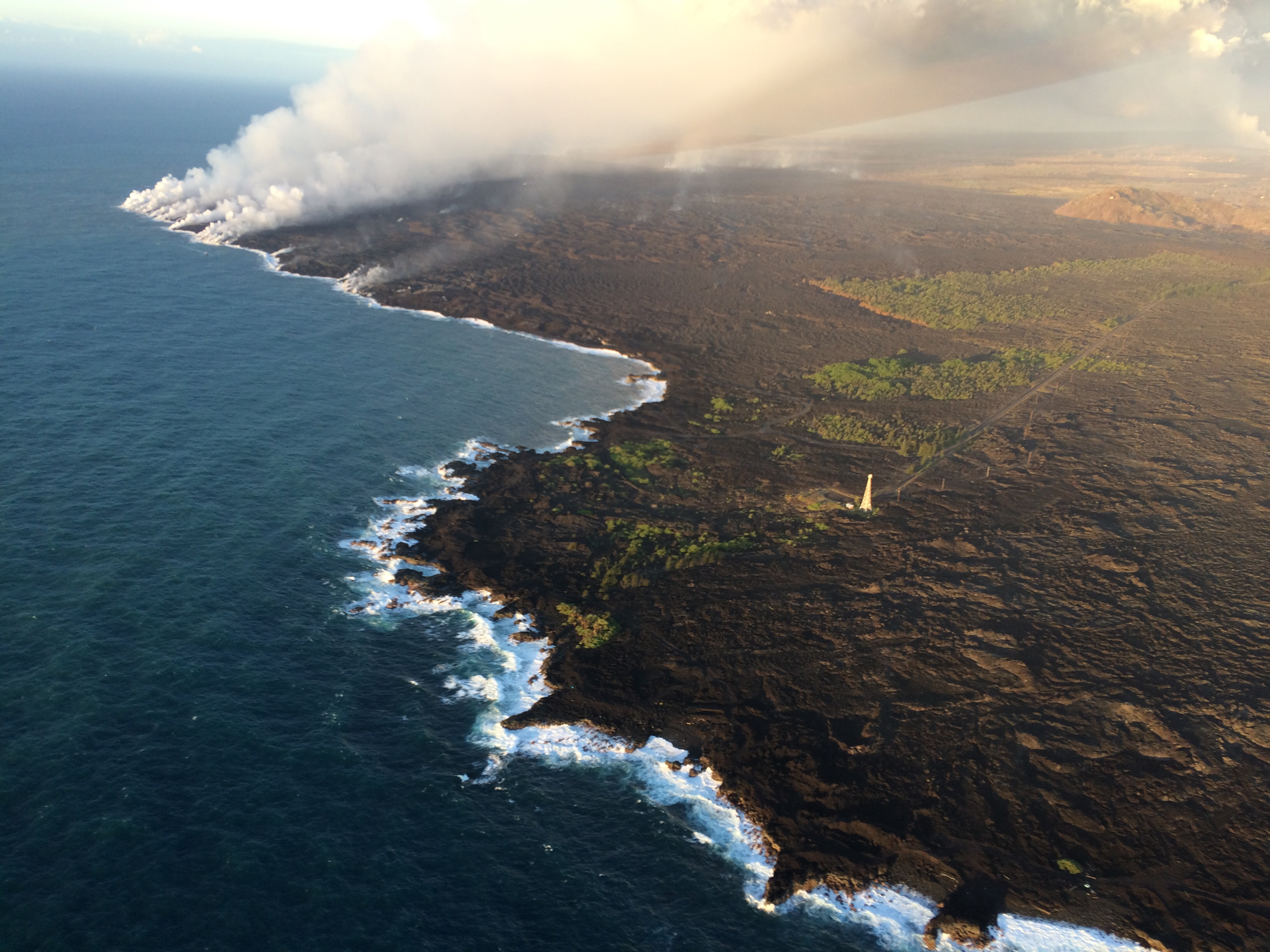
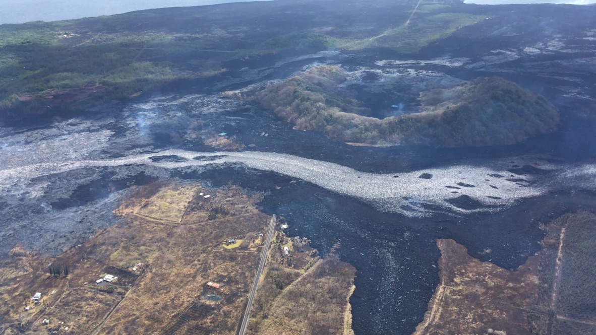
Janet Babb, USGS:  On the Lower East Rift Zone, Fissure 8 continues to erupt, and overnight the channelized flow that was diverted from the main channel that went west of Kapoho Crater advanced to the ocean, and, unfortunately, in its path, it destroyed the Kua O Ko La Charter School and the Ahalanui Beach Park area. And there’s now a new, very robust ocean entry plume near the Ahalanui Beach Park area. So in all, the flow front at the ocean now is about 3.7 miles wide.

In this morning’s overflight, there were no other fissures that appeared to be active.

At the summit, following yesterday’s early morning collapse/explosion that released energy equivalent to a magnitude 5.3 earthquake, the earthquakes have resumed— there was a period of quiet, but the earthquakes have resumed and currently the summit area is experiencing about 25-30 earthquakes per hour. This pattern is expected to continue.

As far as gas emissions at the summit, the gas emissions remain low, and on the Lower East Rift Zone, the gas emissions remain high. And with that, of course, the problems with vog continue with those high emissions.

Continue reading July 12: USGS Conference Call

July 11: Overflows and More Homes/Landmarks Lost

July 11, 2018. USGS: “A pāhoehoe flow fed by overflows from the fissure 8 lava channel was active along Nohea Street in the Leilani Estates subdivision this morning.” (Full-sized)
Today’s Eruption Summary

Quite a lot happened today in the LERZ. Fissure 8 started overflowing again about 8:30-9am this morning. Unfortunately, some spillouts on the north side extended past the edges of previous flows, destroying three more homes in Leilani Estates, two on Luana St, one on Nohea.

Another blockage just west of Kapoho Crater last night diverted much of the main lava channel around the west side of the crater’s cone, rejoining the main flow field on the other side. It created a channelized a’a flow which skirted the southern edge of the existing lava field, and was a quarter mile from the coast and Ahalanui Warm Pond by noon.  [Update 10pm HST: I’m seeing several unconfirmed reports on social media that it and Kua O Ka La Charter School were taken by lava late Wednesday afternoon or early evening.]

However, some lava is still being supplied to earlier ocean entry areas, either by still-molten lava that’s permeated the lava delta, or by a lesser supply of new lava following the old route around Kapoho Crater. This lava is working on building a point (it’s still not the easternmost point of the island, although the angle of the left-hand photo makes it appear so):

[full-sized left photo] [full-sized right photo]

Interestingly, today’s tardy summit collapse at 5:46am (M5.3 as usual) seems to have had some effect upon Fissure 8. There’s been speculation that might be occurring, but it wasn’t confirmed until now. According to the HVO update: “The collapse/explosive event this morning was followed by an increase in lava from the fissure 8 vent which has produced small overflows from the upper channel that are threatening a few homes on Nohea and Luana streets.”

July 11, 2018. USGS— in fact this is another Don Swanson photo, according to the FB caption: “A telephoto view of the eastern edge of Halema‘uma‘u taken just two minutes after today’s (July 11) 5:45 a.m. HST collapse explosion event. Steam is intermixed with minor ash that imparts a pinkish-brown color to the plume. The energy released by the event was equivalent to a magnitude-5.3 earthquake.” (Full-sized)

Fissure 22 continues to sputter quietly and intermittently, so the sluggish flow it was emitting a week or so ago has cooled.

July 11 LERZ Lava Flow Map
July 11, 2018. USGS map of LERZ lava flows as of 1pm. Full-sized)

Continue reading July 11: Overflows and More Homes/Landmarks Lost